======================
UPDATE! Intriguing Maldives Islands residents report sighting of ‘low flying jet’
Residents of the remote Maldives island of Kuda Huvadhoo in Dhaal Atoll have reported seeing a “low flying jumbo jet” on the morning of the disappearance of the Malaysia Airlines flight MH370. Whilst the disappearance of the Boeing 777 jet, carrying 239 passengers has left the whole world in bewilderment, several residents of Kuda Huvadhoo told Haveeru on Tuesday that they saw a “low flying jumbo jet” at around 6:15am on March 8.
They said that it was a white aircraft, with red stripes across it – which is what the Malaysia Airlines flights typically look like.Eyewitnesses from the Kuda Huvadhoo concurred that the aeroplane was travelling North to South-East, towards the Southern tip of the Maldives – Addu. They also noted the incredibly loud noise that the flight made when it flew over the island.
Satellite data suggests that the last “ping” was recieved from the flight somwhere close to the Maldives and the US naval base on Diego Garcia.
But the Maldives is not amongst the countries that Malaysian authorities had sought help from in its search for the missing jet.
==============================
The Chinese have started searching their own territory. Could the aircraft be in the Taklamakan Desert in the vast Tarim Basin in Xinjiang?

NASA landsat photo of the Tarim Basin (via Wikimedia)
Xinhua attributes this statement to the Chinese Ambassador in Malaysia which raises more questions than it answers. If no Chinese nationals were involved, the chances of the aircraft being in China ought to decrease – not increase. To start searching their own territory now – 11 days after it may have landed or crashed – is perplexing.
Perhaps the Chinese have discovered loopholes in their radar surveillance?
1. No passenger from Chinese mainland aboard the missing MH370 flight might be involved in hijack or terror attack, Chinese ambassador to Malaysia said on Tuesday. Background check on all passengers from Chinese mainland has found no evidence to support that suspicion, Huang Huikang said.
2. He also said China has started search in the its territory along the northern corridor. Based on latest information, the new search areas encompass a northern corridor stretching approximately from the border of Kazakhstan and Turkmenistan to northern Thailand, as well as a southern one from Indonesia to the southern Indian Ocean.
AFP says that the Northern corridor means that the aircraft could have flown through passes in Western China and for the plane to have reached all the way to Western China (Xinjiang?) suggests some very lax military radar in the early hours of Saturday morning (8th March). And in the Xinjiang Uyghur Autonomous Region an estimated 80% of Xinjiang’s Uyghurs live in the southwestern portion of the region, the Tarim Basin.
The historic Tarim Basin lies at the border of China and Kyrgyzstan and may be one of the last places in Asia to have become inhabited. It is surrounded by mountains.
Its northern boundary is the Tian Shan mountain range and its southern boundary is the Kunlun Mountains on the edge of the Qinghai-Tibet Plateau. The Taklamakan Desert dominates much of the basin.

Tarim River and Tarim Basin in Xinjiang (Wikipedia)
====================
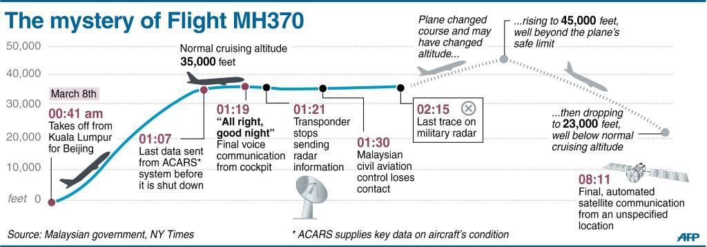
A clear graphic tweeted by Agence France Press
==============
Tags: MH370

March 19, 2014 at 7:40 am
The Maldives are in North Indian Ocean, North of the equator. Diego Garcia is south of the equator, but near it — Neither location are anywhere near the southern corridor?
March 19, 2014 at 7:42 am
Question: Do we know the relative distance of *every* ping since the disappearance near IGREX? If we did, we could just plot it, right?
March 19, 2014 at 7:55 am
I believe that there was only one “ping” picked up by the satellite at 0811 after the radar “disappearance”. There is a complete lack of information between o215 and 0811 – almost 6 hours. That ping contained no location information and the two arcs are based on the geometry of what was visible to the satellite and the possible speed of the plane. (Start of the arc at minimum speed and the furthest point on the arc at maximum speed).
Regarding your previous comment, the Maldives extends a long way North to South — 8°N to 1°S, and I suppose the southernmost point is not that far from the Chagos Archipelago which runs from 3°S to 8°S. Diego Garcia is in the Chagos group.
March 19, 2014 at 3:28 pm
I read there was “One ping per hour” — Yet we were only informed of the last one, not the relative distance of *all* of them during the several hours between IGREX and the last one.
Maldives: That’s still way North compared to the southern corridor, no?
March 19, 2014 at 5:07 pm
I believe the ACARS equipment on board sends a handshake ping, even after being switched off, once an hour as you say. But these pings can only be picked up by the 10 satellites in the Inmarsat network. Inmarsat also says it picked up regular pings.
Why exactly the earlier pings could not be used to indicate a location is not clear to me.
I presume that only the Indian Ocean satellite could generate the arcs (maybe because of its geostationary position?).
The Maldives is not very plausible – but nothing in this story makes any sense.
March 20, 2014 at 9:40 pm
“Why exactly the earlier pings could not be used to indicate a location is not clear to me.” — Wrong question. They simply did not reveal the “relative distance” of each ping publicly.
Only the last one.
March 20, 2014 at 10:08 pm
Yes, you’re right. This excellent Washington Post graphic shows the arcs generated by the earlier pings at 0511, 0611 and 0711 before the final one at 0811.
http://www.washingtonpost.com/national/health-science/satellite-locates-malaysian-flight-370-still-flying-seven-hours-after-takeoff/2014/03/15/96627a24-ac86-11e3-a06a-e3230a43d6cb_graphic.html
March 21, 2014 at 7:40 am
Yes. And we are still missing 2:11, 3:11 and 4:11.