Archive for the ‘Arctic’ Category

Arctic sea ice reaches minimum for 2013 – about a week early

September 6, 2013

A late spring and a short summer has led to Arctic ice melting much slower than for many years: IS ARCTIC SEA ICE REBOUNDING? 

It would seem that the minimum ice extent in the Arctic which usually happens around the middle of September has already been reached – about a week early.

From DMI – Centre for Ocean and Ice (coastal zones masked)

Arctic Sea Ice Extent 2013 minimum

Arctic Sea Ice Extent 2013 minimum

A real rebound in the ice extent and almost back to the level of 2005.

And of course the Antarctic which is reaching its maximum ice extent seems to be at a level significantly higher than the average for 1981 -2010. (NSIDC, Boulder).

Antarctic sea ice extent 20130904

Antarctic sea ice extent 20130904

These levels of ice extent correspond to the lack of significant increase in sea levels.

There does not seem to be very much to be alarmed about.


Arctic summer relatively short and ice melt-rate slow this year

August 9, 2013

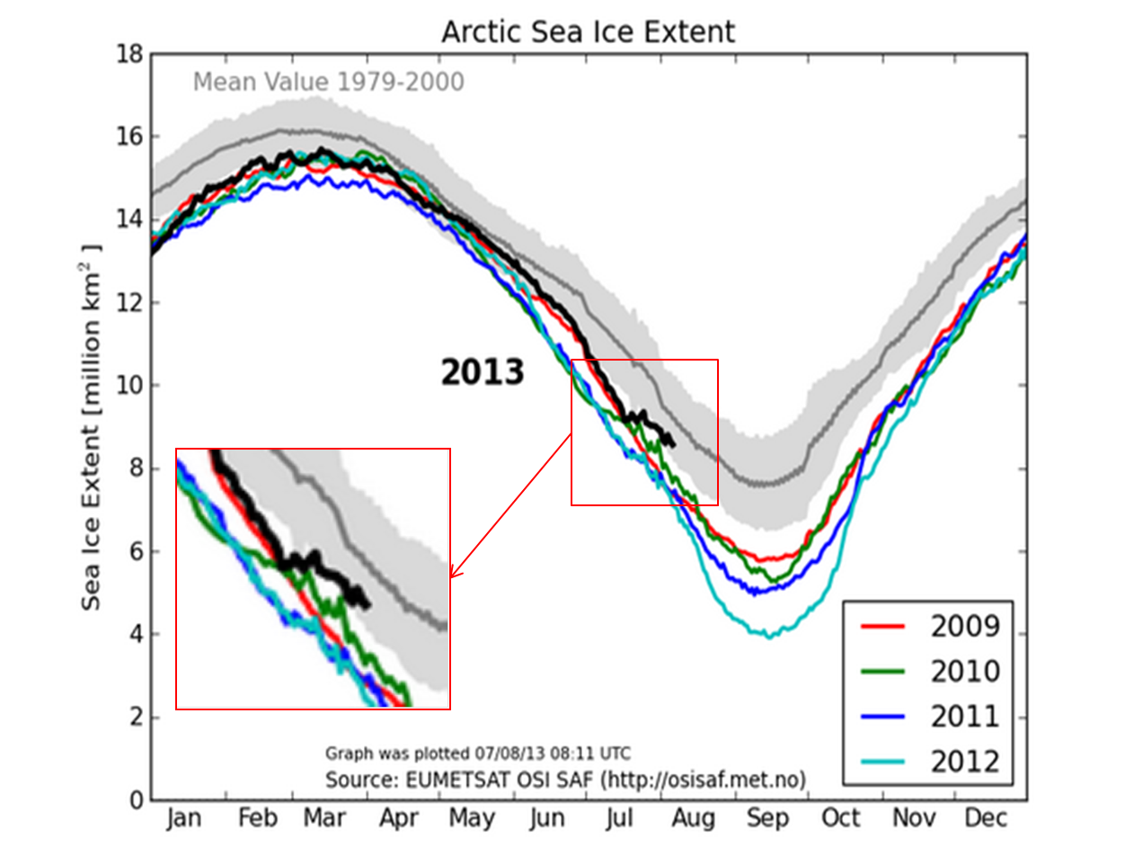
The Arctic ice extent usually reaches a maximum in the 2nd week of March and its minimum during the 2nd week of September.

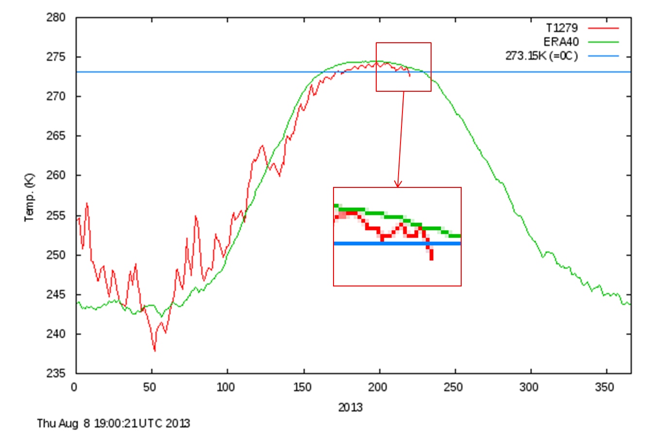
This year the Arctic summer started later than usual (long winter, late spring all over the Northern hemisphere). Now as Arctic temperatures have already dropped below freezing it could turn out to be a rather short. cool summer. Temperatures rose to above freezing about 3 weeks later than the average and seem to have dropped below zero about 2 weeks ahead of the average. In consequence the ice melt-rates have been much lower than for some time (but not unprecedented by a long way).

Arctic Temperatures North of 80° ( from DMI – Danish Centre for Ocean and Ice)

Daily mean temperatures for the Arctic area north of the 80th northern parallel, plotted with daily climate values calculated from the period 1958-2002.

Calculation of the Arctic Mean Temperature

The daily mean temperature of the Arctic area north of the 80th northern parallel is estimated from the average of the 00z and 12z analysis for all model grid points inside that area. The ERA40 reanalysis data set from ECMWF, has been applied to calculate daily mean temperatures for the period from 1958 to 2002, from 2002 to 2006 data from the global NWP model T511 is used and from 2006 to 2010 T799 data are used and from 2010 to present the T1279 model data are used. 

The ERA40 reanalysis data, has been applied to calculation of daily climate values that are plotted along with the daily analysis values in all plots. The data used to determine climate values is the full ERA40 data set, from 1958 to 2002.
More information can be found here.

Daily mean temperature and climate north of the 80th northern parallel, as a function of the day of year. DMI

Daily mean temperature and climate north of the 80th northern parallel, as a function of the day of year. DMI

Not surprisingly the ice melt-rate this year has been relatively low and the ice extent relatively high.

Total sea ice extent on the northern hemisphere during the past years, including climate mean; plus/minus 1 standard deviation. The ice extent values are calculated from the ice type data from theOcean and Sea Ice, Satellite Application Facility (OSISAF), where areas with ice concentration higher than 15% are classified as ice.

The total area of sea ice is the sum of First Year Ice (FYI), Multi Year Ice (MYI) and the area of ambiguous ice types, from the OSISAF ice type product.

Sea ice extent in recent years for the northern hemisphere.                        The grey shaded area corresponds to the climate mean                       plus/minus 1 standard deviation.

Sea ice extent in recent years for the northern hemisphere.
The grey shaded area corresponds to the climate mean plus/minus 1 standard deviation.

It looks probable that the ice extent minimum for 2013 will be within one standard deviation of the mean 1979-2000 value.

Polar bears heading out onto rapidly forming Arctic sea ice

November 17, 2012

In spite of all the headlines about the dearth of Arctic ice it seems that polar bears are not too worried. They are heading out onto the rapidly growing ice in a “mass exodus” to hunt for their seals about a week ahead of  schedule. 

Polar Bear Science reports that:

It appears from the ice maps that most of the polar bears throughout the world that have chosen to remain on land during the late summer and fall (about July/August through October/November) can now return to the ice. …

… polar bear watchers in and around Churchill Manitoba (in Western Hudson Bay) are reporting an exodus of polar bears to the sea ice that is rapidly forming offshore. While it appears from the ice map …. that only a narrow strip of sea ice has formed close to shore, this is apparently quite enough for the bears to move off the land and out to sea. Once on the ice, polar bears will start hunting for seals.

The same phenomenon is likely true all over the Arctic – ice forming near shore may not be showing up on the satellite images (e.g. western Russia, Svalbard) but it will be enough to get polar bears off land and back out to sea where they can hunt. ….

…. Kelsey says that the “bay froze about a week earlier than last year” [earlier is good] and reports that polar bears are eagerly moving offshore onto the newly-formed ice.  Sounds like the folks there to promote “Polar Bear Week” won’t find many bears to point cameras at.

Polar Bear Alley also reports:

This whole season has been about a week ahead of last year so it is not a real surprise that the bay froze about a week earlier than last year. Yesterday, we watched the mass exodus of polar bears out onto the sea ice. Most of the day consisted of yellow bear butts wobbling and weaving out towards the floe edge.

Over the past week, there have been daily highs around minus 10-15C and some fairly consistent north winds. This combination is all we need for the ice to freeze along Cape Churchill. From wind and greasy waves last Thursday to a thin band of ice along the shore by Saturday, you could see the end was near.

Most years though a late season south wind ‘saves’ bear season but this wind arrived about a day or two late this year, the ice is now locked in from what I can see. By Monday, ice floes clung to the shore and the smaller bays near Churchill were almost locked in. A north wind that night and the next day then sealed the deal.

Yesterday, there was a constant stream of polar bears crossing Cape Merry, the point between town and the Churchill River. Polar Bear Alert officers hazed some of them to speed their departure but really, once the ice is here, there is not much incentive to stay around. By 3pm, you could see twelve bears out on the ice between Eskimo Point to the west and Miss Piggy beach. ……

Polar bear numbers in Canada “likely the highest there has ever been”

April 6, 2012

Polar bears near Churchill, Manitoba: Ward Kennan photolibrary

DNA studies have shown that polar bears and brown bears have a common ancestry. The genetic split occurred about 150,000 years ago in the late Pleistocene just before the end of the Pleistocene glaciation known as the Ice Age. They evolved to meet the conditions of the Ice Age and they continue to adapt. In their present form as polar bears they have survived previous interglacials with temperatures greater than we have at present. And far from being endangered and under threat of extinction they continue to adapt their behaviour and to prosper.

New surveys have shown that 

(more…)