Archive for the ‘Weather’ Category

Sun, wind and cloud but nary a glimpse of CO2

February 5, 2021

We have been having a pretty cold spell for the last 10 days and this will probably continue for another 2 weeks. This morning it was -18C

It is the time of the year of course. But, every day we experience the effects of where the weather is coming from, the direction of the wind, the presence of the sun and the mitigating effect of clouds (moisture in the air). The difference between a cloudy night and a clear night is over 10C. The difference between a sunny day and a cloudy day is also about 10C. The effects of CO2, if any at all, are insignificant for my weather.

Climate is merely a label for the integral of weather over space and time. But what is actually experienced is weather and weather does not care very much about CO2.

Interestingly at temperatures below -10C, my heat pumps and electricity usage are at full blast and I cannot charge my hybrid car. The battery charger draws 7kW and when it’s really cold it causes one phase to trip. So my fossil fuel use (petrol) is maximised.

It makes sense that fossil fuels will be needed especially in cold weather and when the next ice age comes. But CO2 does not affect the weather.


Indian monsoon defies Covid 19 and climate change – stays normal

October 1, 2020

The monsoon season (1st June – 30th September) in India is over.

Total rainfall (957.7mm) was 8.7% above the long term average (1961 – 2010) which counts as being normal (+/- 10%).

It does not seem to have been affected by Covid 19, the US election, or alleged man-made climate change.


California normal

April 17, 2017

So much for the global-warming induced, permanent drought that had afflicted California. Population in California has doubled since 1979 but water resources infrastructure has not changed much. Ground water is being consumed and depleted at an increasing pace. Yet normal weather variations are taken to be man-made global warming.

California remains normal, but Californians …….

USNews: 

An index of precipitation at eight sensors showed that just under 90 inches of rain and snow have fallen this winter in the northern Sierra Nevada. The previous record of 88.5 inches was set in the winter of 1982-1983. The average for the region is 50 inches a year, according to the state Department of Water Resources.

The record was surpassed less than a week after Gov. Jerry Brown officially declared an end to California’s drought emergency — a largely symbolic pronouncement that left in place some water-conservation rules for the 40 million residents of the nation’s most populous state.

More snow and rain is likely to pad the record before the wet season ends.


Highest level of November snow in Stockholm for 111 years

November 9, 2016

Dagens Nyheter is one of the most “politically correct” newspapers in Sweden. It believes – not in mono-cultural, multi-ethnicity (which works) – but in fractured multi-culturalist societies (which don’t). It believes people should get what they desire and not what they deserve.

And it believes in the religion of global warming being due to man-made emissions of carbon dioxide.

No doubt the record snowfall in Stockholm will also prove “global warming”.

snow in Stockholm 9th November 2016 — photo TT (via DN)

Dagens Nyheter: 

The worst snowfalls in Stockholm in 111 years.
It has not snowed in Stockholm this early in the winter since SMHI statistics started in 1905.

“It’s about record levels, which, on Thursday morning, will be  official”, says Stina Kihlgren, meteorologist at SMHI. A formal measurement of snow depth is made only once a day in Stockholm, 07:00 each morning at the Observatory. When Stockholm woke up on Wednesday ,SMHI measured 21 centimeters of snow. At midday there was an unofficial listing that showed 30 centimeters. “And then the snow continued to fall. It has been between 30 and 40 centimeters in total. The probability is very high that there will be a new record”, says Stina Kihlgren.

She refers to the measured snow depth in Stockholm in November, where the previous peak was in 1985 at 29 centimeters. “The snow has fallen for several days, it has been very intense.” 

But not to worry. As global temperature numbers continue to be fiddled with new algorithms every year, the snow will, no doubt, disappear.


The US has not been hit by a “major” hurricane since 2005 as Matthew passes by Florida

October 7, 2016

Correction! “major hurricanes” rather than “hurricanes” as pointed out by a reader.


The devastation that Hurricane Matthew has wrought in Haiti was real and the death toll is approaching 500. However it has moved away and Florida has escaped landfall. It has now been over 4,000 days since Hurricane Wilma made landfall in Florida as a major hurricane with category 3 winds (wind speeds of categories 1 and 2 are considered storms and not hurricanes still hurricanes but not “major hurricanes”) in October 2005. “Hurricane Sandy” in 2012 had category 1 winds at landfall.

Florida has surely suffered damage from Matthew passing by – but it was not by the landfall of a major hurricane. Matthew’s winds are now at category 3 and are expected to reduce to strength 2 later today. The US major hurricane drought continues. Could that possibly be due to “global warming”? I would put any “hurricane season” down to weather and not to climate. That there is a hurricane season at all is surely a climate characteristic.

I am reproducing Dr. Roy Spencer’s post on his blog which says it all:

4,001 Days: The Major Hurricane Drought Continues

October 7th, 2016 by Roy W. Spencer, Ph. D.

Also, The Hurricane Center Doesn’t Overestimate…But It Does Over-warn

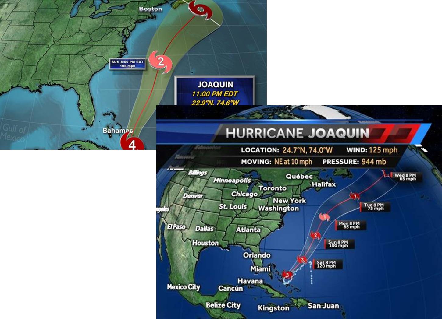
Today marks 4,001 days since the last major hurricane (Wilma in 2005) made landfall in the United States. A major hurricane (Category 3 to 5) has maximum sustained winds of at least 111 mph, and “landfall” means the center of the hurricane eye crosses the coastline.

This morning it looks like Matthew will probably not make landfall along the northeast coast of Florida. Even if it does, its intensity is forecast to fall below Cat 3 strength this evening. The National Hurricane Center reported at 7 a.m. EDT that Cape Canaveral in the western eyewall of Matthew experienced a wind gust of 107 mph.

(And pleeeze stop pestering me about The Storm Formerly Known as Hurricane Sandy, it was Category 1 at landfall. Ike was Cat 2.)

While coastal residents grow weary of “false alarms” when it comes to hurricane warnings, the National Weather Service has little choice when it comes to warning of severe weather events like tornadoes and hurricanes. Because of forecast uncertainty, the other option (under-warning) would inevitably lead to a catastrophic event that was not warned.

This would be unacceptable to the public. Most of us who live in “tornado alley” have experienced dozens if not hundreds of tornado warnings without ever seeing an actual tornado. I would wager that hurricane conditions are, on average, experienced a small fraction of the time that hurricane warnings are issued for any given location.

The “maximum sustained winds” problem

Another issue that is not new is the concern that the “maximum sustained winds” reported for hurricanes are overestimated. I doubt this is the case. But there is a very real problem that the area of maximum winds usually covers an extremely small portion of the hurricane. As a result, seldom does an actual anemometer (wind measuring device) on a tower measure anything close to what is reported as the maximum sustained winds. This is because there aren’t many anemometers with good exposure and the chances of the small patch of highest winds hitting an instrumented tower are pretty small.

It also raises the legitimate question of whether maximum sustained winds should be focused on so much when hurricane intensity is reported.

Media hype also exaggerates the problem. Even if the maximum sustained wind estimate was totally accurate, the area affected by it is typically quite small, yet most of the warned population is under the impression they, personally, are going to experience such extreme conditions.

How are maximum sustained winds estimated?

Research airplanes fly into western Atlantic hurricanes and measure winds at flight level in the regions most likely to have the highest winds, and then surface winds are estimated from average statistical relationships. Also, dropsonde probes are dropped into high wind regions and GPS tracking allows near-surface winds to be measured pretty accurately. Finally, a Stepped Frequency Microwave Radiometer (SFMR) on board the aircraft measures the roughness of the sea surface to estimate wind speed.

As the hurricane approaches the U.S. coastline, doppler radar also provides some ability to measure wind speeds from the speed of movement of precipitation blowing toward or away from the radar.

I don’t think we will solve the over-warning problem of severe weather events any time soon.

And it looks like the major hurricane drought for the U.S. is probably going to continue.


Monsoon season is over but the rain continues as withdrawal lags

October 3, 2016

The monsoon season “officially” runs through June, July, August and September. This year it was about a week late in being established and now, at the end of the season, total rainfall has been about 3% lower than the long-term average and it counts as a normal monsoon (just).

Predictions of a better than average monsoon have been proven wrong . But have they?

The monsoon does not much care about calendar dates and the withdrawal of the monsoon is running about 2 weeks behind its “average” schedule.

graphic imd

graphic imd

It looks like monsoon rains will continue sporadically over the next 15 – 20 days. Currently the rains stretch across central India from Gujarat to Bihar. The total rainfall – though not conforming to the official calendar – may well be slightly above average.

Once it has finally withdrawn the verdict is likely to be that the 2016 monsoon was “good”.


We’re having a heat wave, …..

January 18, 2016

After 16 consecutive days with daily high temperatures between -12ºC and -18ºC, and daily lows between -15ºC and -24ºC, a blast of hot air is now passing over us from the south west. For about 12 hours we are told we may see temperatures as high as -6ºC before returning to less than -12ºC for the rest of the week.

Though the sun rises at 0831 and sets at 1543, the days are getting perceptibly longer.

Roll on summer.

heat wave 20160118

heat wave 20160118

We’re having a heat wave
A tropical heat wave
The temperature’s rising
It isn’t surprising …

Irving Berlin

In winter we spend most of our time in heated spaces at around +20ºC. In summer we cool our spaces to about 22-24ºC. We are after all, evolved for tropical climates.

If only the global warming fantasy were true (which it isn’t).


Hurricane Patricia – 200 became 165, potentially catastrophic became no significant damage – why the hype?

October 24, 2015

It was the strongest storm ever recorded. It was the most dangerous storm in history. Such strong winds had never been recorded before. It was going to cause catastrophic damage. The banner headlines were spread in the mainstream media across the globe.

But Patricia has fizzled to a Category 2 storm just a few hours after landfall. No serious damage so far.

Was there an agenda to the world-wide hype? Remember the hype about Hurricane Joaquin just a few weeks ago. It didn’t even make landfall and in the course of just a few days the forecast course changed by some 6,000km. Remember Typhoon Haiyan. Strongest ever winds of 200 MPH  were predicted hours before landfall. By the time it made landfall it was a tropical storm. Is there a pattern to the hype?

Hurricane Joaquin post mortem -- tracks from RealScience

Hurricane Joaquin post mortem — tracks from RealScience

This morning I learn that Hurricane Patricia has made landfall and is weakening. The expected 200mph winds had become less than 165mph by landfall. From Category 5 it has been downgraded to Category 2. So far minor landslides and fallen trees have been reported. How come they were “destructive winds and rain” but “heavy damage was avoided”? Destructive without damage? We used to call that non-destructive.

BBC: 

The storm touched down in western Mexico, bringing destructive winds and rain, but heavy damage appears to have been avoided.

The US National Hurricane Center said the hurricane hit as a Category Five storm – the highest classification.

It said “life-threatening flash floods and mudslides” were now likely.

The states of Nayarit, Jalisco, Colima, Michoacan, and Guerrero are in particular danger as the storm moves inland, the centre says.

Four hours after making landfall as the strongest recorded hurricane, Patricia weakened to a Category Four, and is likely to be downgraded to a tropical storm in the coming hours as it passes over mountainous regions.

“The first reports confirm that the damage has been smaller than that corresponding to a hurricane of this magnitude,” Mexico’s president, Enrique Pena Nieto, said in a televised address.

Mexican federal police said only “minor landslides and fallen trees” had so far been reported in Colima.

I don’t suppose that the hype has anything to do with the approaching Paris conference on wealth distribution (ostensibly about global warming)?

I note that Mexico is expecting to be a beneficiary from the Paris largesse.

Hurricane Joaquin moves away

October 3, 2015

US hurricane strikes are at an all-time low and there has been much alarmist excitement this week about the possibility of hurricane Joaquin striking the US mainland. First, it was going to strike N Carolina. Emergencies were declared. Then it was going to hit New York. Emergencies were extended. The hurricane declined to follow the computer models. Now Boston and New England were the targets claimed the modellers. Hurricane Joaquin moved even slower and moved further East.

The latest is that it is now headed for Bermuda. Some of the UK media are now concerned it may hit the UK. Not to underestimate the power of the hurricane since a cargo ship with 33 on board which was near the eye has gone missing. But, so much for the infallibility of computer models which claim that climate is a settled “science”. “It is weather that is variable and unpredictable”, I hear them cry. “The climate is perfectly predictable and the science is settled”. Ah Yes. But climate is nothing more than weather integrated over space and time.

Modellers who change the data rather than change their mathematical models which don’t fit reality, ought to be beyond the pale. But apparently it is acceptable to fudge data if it preserves political correctness.

Joaquin 1

Joaquin 2

This image from RealScience shows how the predicted track has moved.

In spite of the alarm of extreme weather the reality is that US hurricane strikes are at an all-time low.

Data from:  HURDAT Re-analysis Chronological List of All Hurricanes

A year without summer in the Cairngorms and in the highlands of Lapland

August 15, 2015

It is successive cool summers and the persistence of snow and ice from one winter to the next which will cause the next little ice age. Of course the absence of summer in the highlands of Lapland and Scotland in 2015 does not necessarily mean that an ice age is upon us. But in the language of “climate science” (which is no science), it is entirely consistent with the coming of an ice age.

This year we have had a fairly miserable summer in Sweden but in the highlands of Lapland, conditions have gone directly from a “meteorological spring” to “meteorological autumn”. And even in the Scottish Cairngorms snow from last winter is still persisting and creating some impressive sculptures as it melts.

Telegraph: Low summer temperatures mean snow continues to cling to the mountainsides of the Scottish National Park, even in the middle of August. But as the patches begin to melt from below, and water flows downhill, vast caverns – some big enough to walk through – are formed.

These striking pictures were captured by Helen Rennie at Ciste Mhearad in the northern Cairngorms.

Melting snow leaves behind magical frozen caves in Scotland

Helen Rennie at Ciste Mhearad Photo: Helen Rennie

In Lapland, the highlands have officially skipped summer and gone directly from spring to autumn conditions.

Swedish Radio:

There was no summer this year in the Tarfala highlands of northern Lapland. They have gone from meteorologic spring to autumn without going through any summer according to the temperatures says SMHI meteorologist Sandra Andersson. “If the summer has not formally come by 1st August we can go directly to autum instead and so it was for Tarfala” says Sandra Andersson.

How common is it to skip a season? “In the highlands it happens occasionally. Even Falsterbo in Skåne (southern Sweden) have sometimes skipped winter but it is not so common”

Even in Stekenjokk in the southern highlands of Lapland it is is now officially autumn, which means that the average temperature during the day after 1st August did not exceed ten degrees for five days in a row. 

Kebnekaises sydtopp. Foto: Stockholms universitet.

Southern top of Kebnekaise Foto: Stockholms universitet.


%d bloggers like this: