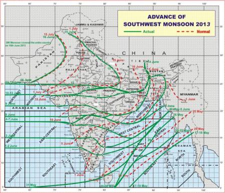
Yesterday the monsoon covered the entire country but while this is only 2 days later than the “long term average”, the progress of the monsoon across south and central India has been around a week or 10 days late. Until last week the rainfall was in deficit by over 40%, but heavy rains this week are beginning to eat into this deficit. In the meantime the possibility of a strong El Niño this year, which could have further depressed the monsoon rainfall, is receding.
With 2½ months of the monsoon season left, there is now a reasonable – and improving – probability that the shortfall will end up at less than 10% of the long term average and that the hit to the Indian GDP will not be too severe.
Climate alarmists (mainly the environmental mafia) have been hoping – and praying – for a strong El Niño, a disastrous monsoon, a strong blow to the agricultural sector and an increase in farmer suicides. They are increasingly likely to be disappointed. Fortunately the cost to consumers usually reduces and the good of society usually increases with the increasing disappointment of the loony green mafia.
The best thing to have happened for Australia in years is probably the recent repeal of the Carbon tax which has – surprise, surprise – caused great disappointment to the loony green mafia.
ET:The monsoon delivered this season’s heaviest showers on Tuesday, drenching southern and central India with 50 per cent more rainfall than normal, while international forecasters said the rain-disrupting El Nino phenomenon would be weaker than feared.
The northern and western parts of the country remained relatively dry, but for the country as a whole, Tuesday’s rainfall was 10 per cent above normal, reducing the season’s rain deficit to 40 per cent. The deficit is still abnormally high, but two days of heavy rainfall is expected to speed up crop planting, which was half of last year’s mid-July level.
The weather office has forecast good rainfall in many parts of the country in the days ahead. Further, the latest forecast of Australia’s weather department could bring some relief to policy-makers as it has suggested that the El Nino weather phenomenon that curtails June-September rains is unlikely to be intense this year.
The Australian Bureau of Meteorology writes in its ENSO wrap-up:
Warming of the tropical Pacific Ocean over the past several months primed the climate system for an El Niño in 2014. However, a general lack of atmospheric response over the last month has resulted in some cooling of the tropical Pacific Ocean.
While the majority of climate models suggest El Niño remains likely for the spring of 2014, most have eased their predicted strength. If an El Niño were to occur, it is increasingly unlikely to be a strong event.
Changes are also occurring in the Indian Ocean. The Indian Ocean Dipole (IOD) index has been below −0.4 °C (the negative IOD threshold) since mid-June, but it would need to remain negative into August to be considered as an event. Negative values are rare when the central Pacific is warmer than average. Model outlooks suggest the IOD is likely to return to neutral by spring. Conditions in the Indian Ocean may have contributed to the above-average rainfall experienced in southeast Australia during June.


