Archive for the ‘Weather’ Category
February 1, 2011
The Australian BoM warning for northern Queensland is being couched in stronger language as Cyclone Yasi has intensified to category 5. This is the highest level on the Seffir-Simpson Scale and Category 5 is reserved for storms with winds exceeding 155 mph (69 m/s; 135 kn; 249 km/h).
SEVERE TC YASI IS A LARGE AND VERY POWERFUL TROPICAL CYCLONE AND POSES AN EXTREMELY SERIOUS THREAT TO LIFE AND PROPERTY WITHIN THE WARNING AREA, ESPECIALLY BETWEEN PORT DOUGLAS AND TOWNSVILLE.
THIS IMPACT IS LIKELY TO BE MORE LIFE THREATENING THAN ANY EXPERIENCED DURING RECENT GENERATIONS.
The Cyclone has now reached CATEGORY 5 and will continue to move in a west-southwesterly direction during today.

image: bom.au.gov
| Forecast Location and Intensity Number |
 |
| Very Destructive Wind Boundary |
 |
|
|
|
| Destructive Wind Boundary |
 |
| Strong Gale Force Wind Boundary |
 |
| Most Likely Future Track |
 |
| Range of Likely Tracks of Cyclone Centre |
 |
Tags:Category 5, Cyclone Yasi, Queensland, Saffir–Simpson Hurricane Scale
Posted in Australia, Natural Disasters, Weather | Comments Off on Cyclone Yasi intensifies to category 5
February 1, 2011
Northern Queensland is bracing itself for Cyclone Yasi which is now expected to cross the coast at about 1am on Thursday morning (3rd February).
The Australian BOM has this warning:
YASI IS A LARGE AND POWERFUL TROPICAL CYCLONE AND POSES A SERIOUS THREAT TO NORTH QUEENSLAND COMMUNITIES
Cyclone Yasi track: image bom.gov.au
- The cyclone is expected to slowly intensify overnight as it moves westwards over the Coral Sea.
- SEVERE TROPICAL CYCLONE YASI, CATEGORY 3 is expected to turn on a more west-southwesterly direction in the next 12 hours.
- DAMAGING winds with gusts to 90 km/hr are expected to develop on the islands during Wednesday morning, then extend onto the coast during the day, and further inland across southern Cape York Peninsula and north of Charters Towers overnight.
- Between Cooktown and Townsville these winds will become DESTRUCTIVE with gusts in excess of 125km/hr late Wednesday afternoon.
- As the centre approaches the coast sea levels will rise above the normal tide with damaging waves and flooding of low lying areas near the shoreline.
- Flooding rains will develop from Cooktown to Sarina during Wednesday afternoon and then extend inland overnight.
- People between Cooktown and Sarina should immediately commence or continue preparations, especially securing boats and property [using available daylight hours/before nightfall].
SMH reports that forced evacuations are are now taking place:
Authorities doorknocking homes in north Queensland are now ordering people to leave their properties, as severe Tropical Cyclone Yasi bears down.
Queensland Premier Anna Bligh said this afternoon councils between Cook and Hinchinbrook shires had given the go-ahead for forced evacuations to be carried out, amid fears a storm surge would cause water levels to rise by two metres.
She said officials who were door-knocking homes in high-risk areas now had the power to issue directives for people to leave.

Cyclone Yasi approaches the Australian coast from the Coral Sea. Photo: Reuters/Japan Meteorological Agency
Tags:Cairns, Cyclone Yasi, North Queensland, Tropical cyclone
Posted in Australia, Natural Disasters, Weather | Comments Off on Cyclone Yasi is intensifying and closing
January 31, 2011
The threat from Cyclone Anthony has passed but Cyclone Yasi is approaching and due to hit the coast on Thursday. One blessing is that it is moving so fast that it may not have time to dump much water over the water-logged regions of Queensland.
BOM advice:
Damaging winds are expected to develop about coastal and island communities between Cooktown and Yeppoon Wednesday morning. People between Cooktown and Yeppoon should consider what action they will need to take if the cyclone threat increases.
The forecast path shown above is the Bureau's best estimate of the cyclone's future movement and intensity: image BOM
Tags:Cyclone Anthony, Cyclone Yasi, Queensland
Posted in Australia, Weather | Comments Off on Cyclone Yasi approaches Queensland coast
January 30, 2011
Ria Novosti today:

MOSCOW, January 30 (RIA Novosti) 18:45 30/01/2011
The Russian icebreakers Krasin and Admiral Makarov have rescued the ice-trapped mother fishery ship Sodruzhestvo ending the month-long operation in the Sea of Okhotsk.
“The operation to rescue the Sodruzhestvo mother ship out of ice trap has been completed,” Russia’s Ministry of Transport said in a statement on Sunday.
The icebreakers resumed towing the vessel, stuck in the Sea of Okhotsk, toward clear waters on Wednesday. The rescue operation was earlier suspended due to poor weather conditions.
The Sodruzhestvo, Bereg Nadezhdy ship and the Professor Kizevetter research vessel, carrying altogether over 400 people, got stuck in two-meter-thick ice in the Sea of Okhotsk on December 31. Two other ships, the Mys Yelizavety and the Anton Gurin, became trapped a few days later.
The Admiral Makarov released the Professor Kizevetter and the Mys Yelizavety vessels from the ice trap, while the Anton Gurin managed to cope on its own. The Bereg Nadezhdy was successfully towed to clear water on January 24.
Tags:Icebreaker Admiral Makarov, Icebreaker Krasin, Russia, Sea of Okhotsk
Posted in Engineering, Environment, Russia, Technology, Weather | Comments Off on Okhotsk rescue over and icebreakers end operations
January 30, 2011
After the floods (even if some of the flooding in Brisbane was due to poor operation of the Wivenhoe Dam), Queensland faces a cyclone due to cross the coast today and another larger cyclone which could hit on Thursday.
SMH reports:

An infra-red image shows Cyclone Anthony bearing down on the Queensland coast, with a large tropical depression off Vanuatu expected to develop into another, more devastating cyclone. Photo: US National Environmental Satellite, Data and Information Service
The two cyclones bearing down on the Queensland coast could be a case of “David and Goliath”, with the second system expected to be bigger and more devastating, Premier Anna Bligh said today.
Cyclone Anthony intensified to a category-two system just before 2pm (local time) today and is expected to cross the coast between Ayr and Bowen, in north Queensland, late tonight. …….
Cyclone Anthony was at 5pm located 255 kilometres east of Townsville and 125 kilometres northeast of Bowen, with a warning zone stretching along the coast from Lucinda to Sarina, the Bureau of Meteorology said. The bureau tonight warned of destructive wind gusts up to 130km/h and abnormally high tides between Ayr and Bowen, with large waves likely along the beachfront between Townsville and Sarina. It said heavy rainfall and flooding was developing about the coast near and to the south of the cyclone, extending as far south as Sarina. Gales up to 100km/h were battering Hamilton Island late this afternoon.
However, the bureau is more worried about Cyclone Yasi, lurking near Vanuatu, which could potentially cross the Queensland coast on Thursday morning. The meteorological centre in Fiji this afternoon upgraded the low-pressure system to a category-one cyclone, which was moving west at 13km/h and intensifying.
The prospect of two cyclones crossing the Queensland coast within four days of each other comes after three quarters of the state was recently declared a disaster zone in the wake of devastating flooding. ……. Ms Bligh today described the two cyclones as “David and Goliath”, with Cyclone Anthony expected to be “quite smaller than the second event”.
But Ms Bligh said Anthony should not be underestimated, with wind gusts of more than 120km/h likely and damage expected.
Tags:Cyclone Anthony, Cyclone Yasi, Queensland, Queensland floods, Wivenhoe Dam
Posted in Australia, Natural Disasters, Weather | Comments Off on Now Queensland faces “David and Goliath” cyclones
January 17, 2011

The Krasin: Image via Wikipedia
The rescue of the ships trapped by ice in the Sea of Okhotsk has been completed. A tour de force at temperatures as low as – 27°C by the three ice breakers, Magadan, Admiral Makarov and Krasin. The Krasin joined last and was the star of the show.
Richard North has been following and anticipating the story and a more complete description of this admirable rescue is available here.
This morning from Ria Novosti:
http://en.rian.ru/russia/20110117/162171301.html
07:04 17/01/2011The Krasin and Admiral Makarov icebreakers have managed to take the Sodruzhestvo mother fishery ship and the Bereg Nadezhdy refrigerator vessel out of thick ice in the Sea of Okhotsk, the Far Eastern Shipping Company said Monday.
“The icebreakers first towed the mother ship to a safer area, and then returned for the Bereg Nadezdy, which they took to thinner ice,” company spokeswoman Tatyana Kulikova said.
The Bereg Nadezhdy ship, the Professor Kizevetter research vessel, and the Sodruzhestvo mother fishery ship, carrying altogether over 400 people, got stuck in two-meter-thick ice in the Sea of Okhotsk on December 31. Two other ships, the Mys Yelizavety and the Anton Gurin, became trapped a few days later.
The Admiral Makarov released the Professor Kizevetter and the Mys Yelizavety vessels from the ice trap, while the Anton Gurin managed to cope on its own.
Then the operation to rescue the Bereg Nadezhdy started, but the two icebreakers changed their plans, returning to the Sodruzhestvo vessel, which was the hardest to tow due to its wide body. Towing ropes snapped soon after the start of the operation, which resumed next day.
The rescue effort has been hampered by strong winds, low visibility and shifting ice floes in the area.
Tags:Admiral Makarov, ice rescue, icebreakers, Krasin, Magadan, Sea of Okhotsk
Posted in Engineering, Environment, Russia, Technology, Weather | 2 Comments »
January 16, 2011
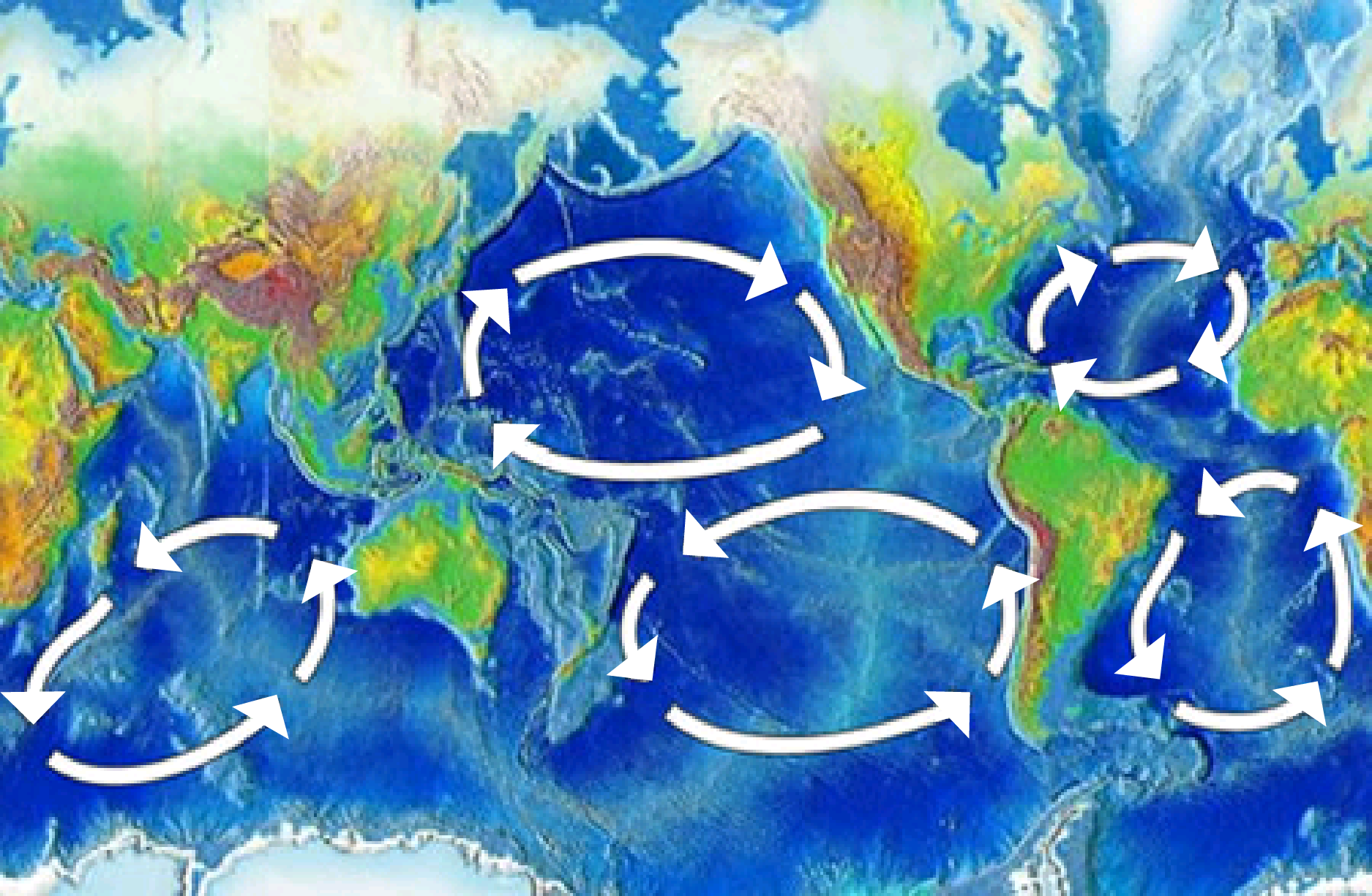
A new paper in Science giving ocean currents in the Atlantic their due (and without finding it necessary to appeal to tales of carbon dioxide). Perhaps the science is not so settled after all!

The five major ocean-wide gyres — the North Atlantic, South Atlantic, North Pacific, South Pacific, and Indian Ocean gyres. Each is flanked by a strong and narrow “western boundary current,” and a weak and broad “eastern boundary current”: Wikimedia
The Deglacial Evolution of North Atlantic Deep Convection. by D. J. R. Thornalley, S. Barker, W. S. Broecker, H. Elderfield, I. N. McCave. Science, 2011; 331 (6014): 202 DOI: 10.1126/science.1196812
Science Daily reports:
… Scientists have long suspected that far more severe and longer-lasting cold intervals have been caused by changes to the circulation of the warm Atlantic ocean currents themselves.
Now new research led by Cardiff University, with scientists in the UK and US, reveals that these ocean circulation changes may have been more dramatic than previously thought. The findings, published January 14, 2011 in the journal Science, show that as the last Ice Age came to an end (10,000 — 20,000 years ago) the formation of deep water in the North-East Atlantic repeatedly switched on and off. This caused the climate to warm and cool for centuries at a time.
The circulation of the world’s ocean helps to regulate the global climate. One way it does this is through the transport of heat carried by vast ocean currents, which together form the ‘Great ocean conveyor’. Key to this conveyor is the sinking of water in the North-East Atlantic, a process that causes warm tropical waters to flow northwards in order to replace the sinking water. Europe is kept warmer by this circulation, so that a strong reduction in the rate at which deep water forms can cause widespread cooling of up to 10 degrees Celsius. ….. The new results suggest that the Atlantic ocean is capable of radical changes in how it circulates on time scales as short as a few decades.
Dr Thornalley said: “These insights highlight just how dynamic and sensitive ocean circulation can be. Whilst the circulation of the modern ocean is probably much more stable than it was at the end of the last Ice Age, and therefore much less likely to undergo such dramatic changes, it is important that we keep developing our understanding of the climate system and how it responds when given a push.”
Paper Abstract:
Deepwater formation in the North Atlantic by open-ocean convection is an essential component of the overturning circulation of the Atlantic Ocean, which helps regulate global climate. We use water-column radiocarbon reconstructions to examine changes in northeast Atlantic convection since the Last Glacial Maximum. During cold intervals, we infer a reduction in open-ocean convection and an associated incursion of an extremely radiocarbon (14C)–depleted water mass, interpreted to be Antarctic Intermediate Water. Comparing the timing of deep convection changes in the northeast and northwest Atlantic, we suggest that, despite a strong control on Greenland temperature by northeast Atlantic convection, reduced open-ocean convection in both the northwest and northeast Atlantic is necessary to account for contemporaneous perturbations in atmospheric circulation.
Tags:Atlantic Ocean, global cooling, global warming, ice ages, Last glacial period, Ocean currents
Posted in Climate, Geosciences, Oceans, Science, Weather | 1 Comment »
January 15, 2011
Itar-Tass reports.
MOSCOW, January 14 (Itar-Tass) — The Admiral Makarov and Krasin icebreakers, which are leading the Sodruzhestvo mother ship out of an ice trap in the Sea of Okhotsk, have reached the drifting refrigerator ship Bereg Nadezhdy, a source at the Transport Ministry told Itar-Tass.
“The convoy of the Admiral Makarov, the Krasin and the Sodruzhestvo reached the drifting Bereg Nadezhdy at 10:30 a.m. Moscow time on Friday,” he said.
The Admiral Makarov cleared a two-mile strip in the afternoon and returned to the convoy. “The coordinating staff led by Deputy Transport Minister Viktor Olersky is analyzing weather and ice conditions for elaborating the tactics of the further operation,” the source said.
The ships need to cross the ice for meeting with the Magadan icebreaker and the Victoria tanker.
A number of ships trapped in the ice in the Sea of Okhotsk, among them the Sodruzhestvo, the Bereg Nadezhdy, the Professor Kizevetter research ship and the Mys Yelizavety trawler, asked for help on December 31, 2010. Two vessels were taken to a safe area.
It is yet unknown when the rescue of the Sodruzhestvo and the Bereg Nadezhdy may be over, as weathermen have a bad forecast for about one week.
Tags:Icebreaker Admiral Makarov, Krasin, Magadan, Sea of Okhotsk, Sodruzhestvo
Posted in Engineering, Environment, Russia, Technology, Weather | 1 Comment »
January 15, 2011
Climate Science – if there is such a thing – had long ago abandoned science to become a lobby for “global warming theory”. But the “scientists” are plumbing new depths.
It has not taken long for “climate scientists” to claim that all extreme weather events (heat wave in Russia, floods in Pakistan, coldest December in 100 years , droughts in Australia and now floods in Brazil and Australia) are all “not inconsistent with global warming” implying by some strange, convoluted logic that all these weather events (which are also consistent with history repeating itself) somehow add to the body of “evidence” which “proves” that man-made global warming is happening. There have even been crack-pot scientists with such a vested interest in the “man-made global warming” ideology who have found it possible to blame volcanic activity and even the earthquake in Haiti on “global warming”!!!
The current strength of the La Ninã conditions are perfectly consistent with other theories based on ocean variation and the frigid winters are quite consistent with the quiet Sun (which went spotless again yesterday). All current weather is also consistent with man-made effects being totally negligible and instead being dominated by the sun’s cycles and with the oceans as the primary vehicle for transporting heat around the globe. Weather is not climate and in fact none of the “extreme” weather events are outside the range of weather variations that have been experienced over the last 1000 years.
The floods in Brazil have claimed over 500 lives and in Australia – which is far better prepared – the death toll will likely be between 20 – 30. In Australia where a higher flood occurred in 1974 in Brisbane voices are beginning to be raised that the “global warming” lobby have actually prevented the use of dams and implementation of proposed water management policies which could have been able to better manage these regular and recurring flood conditions.
The history of floods in Brisbane is telling:

Highest annual flood peaks for Brisbane
The floods this year in Queensland are nothing new. Why would this flood be evidence of man-made global warming but not the floods of the 1800s? In fact the history of these weather conditions in Brisbane is not inconsistent with global cooling, the coming of an ice-age or an apocalyptic end to the earth in 2012!

thepunch.com.au
Any scientist who is concerned with science and not with religion, politics or defending his past conclusions would know that being “not inconsistent” with some theory carries no weight in a scientific proof – but it does sound so credible in a TV sound-bite.
But we can expect that over the next few years that every natural disaster or extreme weather event will be taken by the members of a dying religion as being “not inconsistent with” and therefore as proof of man-made global warming.
Tags:droughts, floods, global cooling, global warming, La Niña effects, ocean circulation, solar effects
Posted in Alarmism, Climate, Natural Disasters, Science, Weather | Comments Off on “Not inconsistent with man-made global warming” !!
January 14, 2011
La Niña is expected to continue well into the Northern Hemisphere spring 2011.
The latest report from NOAA’s Climate Prediction Center (CPC) noted that “A moderate-to-strong La Niña continued during December 2010 as reflected by well below-average sea surface temperatures (SSTs) across the equatorial Pacific Ocean.” The CPC report said that La Niña is expected to continue well into the Northern Hemisphere spring 2011.
Physorg reports:
New NASA satellite data indicate the current La Niña event in the eastern Pacific has remained strong during November and December 2010.

The La Niña is evident by the large pool cooler than normal (blue and purple) water stretching from the eastern to the central Pacific Ocean, reflecting lower than normal sea surface heights. "This La Niña has strengthened for the past seven months, and is one of the most intense events of the past half century," said Climatologist Bill Patzert of NASA JPL. Credit: NASA JPL/Bill Patzert
A new Ocean Surface Topography Mission (OSTM)/Jason-2 satellite image of the Pacific Ocean that averaged 10 days of data was just released fromNASA. The image, centered on Dec. 26, 2010, was created at NASA’s Jet Propulsion Laboratory (JPL), Pasadena, Calif.
“The solid record of La Niña strength only goes back about 50 years and this latest event appears to be one of the strongest ones over this time period,” said Climatologist Bill Patzert of JPL. “It is already impacting weather and climate all around the planet.”
“Although exacerbated by precipitation from a tropical cyclone, rainfalls of historic proportion in eastern Queensland, Australia have led to levels of flooding usually only seen once in a century,” said David Adamec, Oceanographer at NASA’s Goddard Space Flight Center, Greenbelt, Md. “The copious rainfall is a direct result of La Niña’s effect on the Pacific trade winds and has made tropical Australia particularly rainy this year.”
The new image depicts places where the Pacific sea surface height is near-normal, higher (warmer) than normal and lower (cooler) than normal. The cooler-than normal pool of water that stretches from the eastern to the central Pacific Ocean is a hallmark of a La Niña event.
Related: https://ktwop.wordpress.com/2011/01/12/la-nina-driving-severe-rains-and-floods-in-brazil-and-australia/
Tags:intense La Niña, La Nina, Ocean Surface Topography Mission, weather
Posted in Climate, Environment, Weather | 1 Comment »