UPDATE!
Saturday 12th, 6:30pm Indian Standard Time: Landfall is expected at any time now. So far some 600,000 people have been evacuated or have moved out of harms way. It has been the largest evacuation in India for 23 years.
______
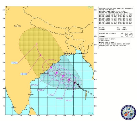
The Bay of Bengal is no stranger to severe weather and severe cyclonic storms occur almost annually. However super cyclones (corresponding to an Atlantic Category 5 Hurricane) occur every 10 -20 years. Fatalities (direct and indirect by subsequent disease) have been huge in this heavily populated area. Super cyclones are defined as having wind speeds in excess of 220km/h and the current Cyclone Phailin is on the edge of that level with winds currently at about 210km/h. The Indian Meteorological Depratment expects the wind speeds to stay at the 210-220 km/h level.
ToI: Foreign agencies claimed Indian authorities are underestimating Phailin, quoting London-based Tropical Storm and US Navy’s joint typhoon warning centre as forecasting winds up to 315 kmph. Indian agencies, however, said wind speeds are much lower.
Super or Severe Cyclone Phailin is expected to make landfall this evening (about 6pm local time Saturday 12th October) somewhere along the Odisha coast. Warnings have been issued and about 200,000 have been asked to evacuate their coastal homes. Relief personnel and police are on alert. The Army has been deployed in some areas. Some 200 tourists have been assisted to leave the area and tourist bookings have been cancelled for upto a week.
Large improvements in the early warning and relief infrastructure have taken place since the catastrophic death toll in the super cyclone of November 1970. But Cyclone Phailin could be the biggest test for Indian preparedness since 1999.
Major super cyclones the region have been:
- 1999, Super Cyclonic Storm 05B, Paradeep Cyclone, 15,000 officially killed, estimated 45,000 dead
- 1991, Super Cyclonic Storm 02B, Bangladesh Cyclone, estimated 138,000 dead
- 1977, Andhra Pradesh Cyclone (6B), 14,000 officially estimated 45,000 dead
- 1970, November Bhola cyclone, estimated 500,000 killed in W. Bengal and Bangladesh
- ……….
- 1885, False Point cyclone, fatalities unknown
- 1876, Backergunge cyclone, estimated 200,000 killed
- 1864, Calcutta cyclone, estimated 80,000 – 100,000 killed.
The projected path of Tropical Cyclone Phailin towards India as of 11:30 a.m. ET on Oct. 10, 2013.
Yahoo News: Experts say that the enormous and powerful storm, with maximum sustained winds of more than 160 mph (260 km/h), will bring a “catastrophic” storm surge, the water that a storm’s winds push in front of it and that inundate a coastline as the storm makes landfall, said Hal Needham, a climatologist at Louisiana State University. The storm surge is expected to reach heights of 20 feet (6 meters), Needham told LiveScience. The storm is likely to be “as bad or worse” than a cyclone that followed a similar trajectory in 1999, called Odisha cyclone for the area it hit.
Times of India: Touching wind speeds of 210-220 km an hour, Cyclone Phailin is set to hit the Odisha coast between Paradip and Kalingapatnam with full fury on Saturday evening, whipping up a storm surge up to 10 feet above the tide level posing a threat to low-lying villages.
Anticipating the cyclone’s fury, the state government began Odisha’s biggest ever evacuation of shifting more than three lakh (300,000) people out of harm’s way as chief minister Naveen Patnaik promised there would be zero casualties. The evacuation is expected to be complete by Saturday morning.
Met sources said the cyclone’s exact landfall is likely to be around the popular beach destination of Gopalpur and coastal Odisha as well as inland areas are expected to receive heavy rainfall likely to last till Sunday.
Although the Met is not categorizing Phailin as a “super cyclone” as it is yet to cross the 220 kmph barrier, there is little doubt that Odisha was bracing for a battering with the storm reported just 400 km south east of Gopalpur at 9pm on Friday. ….
….. Ganjam district is likely to be worst-hit. Other coastal districts falling within 75 km radius of the eye of the storm would also be impacted. “The exact landfall destination of the cyclone can be known once it comes nearly 200 km from the coast. Phailin’s movement however indicates that the situation would not be like the 1999 super cyclone during which the storm lay stationery over the coastal areas for nearly 24 hours and caused a sea surge of about 30 ft. This time 10 ft high wave is expected. More so, the expected landfall area being hilly, the impact of the cyclone would be less and weaken quickly,” IMD Bhubaneswar centre director Sarat Sahu said.
Not leaving anything to chance, the state government began evacuating people from coastal districts of Ganjam, Khurda, Puri, Jagatsinghpur and Kendrapada. Those who refused to leave their homes were forcibly taken to safer places. “There are 247 cyclone shelters and 10,000 concrete schools identified to house the villagers. We want to complete the evacuation by Saturday morning, particularly in Ganjam district which is likely to bear the brunt of the cyclone,” special relief commissioner P K Mohapatra said.
The central government has dispatched 10 helicopters, four Cheetah helicopters and two MI-17 and AN-32 planes to help the state government in rescue and relief operations. The government’s measures notwithstanding, thousands of people from the coastal region were rushing to railway stations and bus stops to escape the cyclone.

