Posts Tagged ‘Volcano’
November 19, 2010
The Indonesian news agency ANTARA reports that:
The government is to end the emergency response period for the Mount Merapi eruption disaster on November 24, a cabinet member said.
“We will maintain the emergency response period until November 24. Whether the period will be extended or not will depend on the situation,” Social Welfare Minister Salim Segaf Al-Jufri said.
Speaking to newsmen on when visiting Magelang district on Thursday, he said Mt Merapi evacuees could return home after the volcano`s “beware” status had been lowered.
After the end of the emergency response period, the National Disaster Management Agency (BNPB) would begin implementing the reconstruction and rehabilitation programs for Mt Merapi victims, he said. “Houses that have been damaged or destroyed will be rebuilt and people who have lost cattle will be financially compensated. The funds to pay for people`s dead cows would be taken from the state and regional government budgets”, he said.
Salim Segaf Al-Jufri further said his ministry had at its disposal Rp397 billion in funds to help disaster victims. Eighty percent of the amount was to meet the victims` physical needs and the rest for operational expenses. But there also was more than Rp3 trillion in stand-by funds to respond to the needs of reconstruction and rehabilitation, he added.
Mount Merapi had erupted repeatedly in the past two or three weeks but its most fatal eruptions occurred on October 26 and November 5. As a result of the eruptions, at least 259 people had perished and many others sustained burns and became displaced.
Topographischer Atlas zur Reise durch Java: Magdeburg, Verlag E. Baensch 1845
via wikipedia.de.
Merapi from the South
Tags:Indonesia, Mount Merapi, Natural Disasters and Hazards, Volcano
Posted in Environment, Geosciences, Indonesia, Natural Disasters | Comments Off on Mount Merapi winds down and Indonesia plans ending of Emergency period
November 15, 2010
Jakarta Globe:
Thousands of Indonesian families returned to their villages Monday even as scientists warned Mount Merapi volcano remained a severe threat and more bodies were found buried in the ash. Carrying their belongings on motorcycles and pickup trucks, more than 30,000 people had left emergency shelters after the government reduced a 20-kilometre (12-mile) exclusion zone by as much as half in certain districts. Most of the returnees were from Boyolali, Klaten and Magelang districts where the danger zone had been reduced.
Mount Merapi, a sacred landmark in Javanese tradition whose name translates as “Mountain of Fire”, had killed 259 people as of Monday’s count. Disaster Management Agency spokesman Sutopo Purwo Nugroho said 367,548 people were still living in shelters on Monday, about 30,000 fewer than on Sunday.
Merapi spewed clouds of gas and ash as high as four kilometres Sunday but volcanologist Subandrio said this was “small compared to the 14 kilometres in previous days”.
“It’s safe for people to go home as long as they stay outside the danger zone,” he added. The government maintained the 20-kilometre danger zone for Sleman district, on the southern slopes of the mountain, as “there’s still a probability of heat clouds going in that direction”, he said.
In another report The Jakarta Globe says that evacuees leaving the camps have been asked to sign waivers before returning home:
About 600 evacuees left two shelters in Boyolali on Friday to return to their homes in the Selo and Cepogo subdistricts. Volunteers at the shelters tried to persuade them to stay, but the evacuees were insistent. Those who wanted to leave were eventually made to sign a statement saying that they were leaving the shelters voluntarily.
“We will still monitor them and give them food aid because food is still scarce at the mountain slopes,” a volunteer told Metro TV. Another shelter located in Tlogo village, Prambanan subdistrict, Klaten, was almost empty. Most of the 1,200 evacuees had returned to their homes, arguing that their cattle and fields were deserted.
Mount Merapi in 1920

Mt. Merapi ca. 1920: Thilly Weissenborn (Fotograaf/photographer). Lux Fotostudio (Fotostudio).wikimedia commons
Tags:evacuees return, Indonesia, Mount Merapi, Volcano
Posted in Environment, Indonesia, Natural Disasters, Volcanos | Comments Off on Merapi Evacuees Ignore Volcano Threat to Go Home
November 11, 2010
The steep-sided, cone-shaped Mount Merapi volcano is both boon and curse to the people of Indonesia. Volcanic ash from its frequent eruptions makes the soil fertile enough to support a large population. It is also one of Indonesia’s most active volcanoes, posing a constant threat to tens of thousands of people who live in its shadow. On October 26, 2010, the volcano once again turned destructive, unleashing a series of eruptions that had killed at least 44 people and forced 75,000 people from their homes, said CNN on November 4.

Eruption at Mount Merapi, Indonesia: Nov 1st: image NASA
The mountain has been shrouded in clouds throughout the eruption, but on October 30 the Advanced Spaceborne Thermal Emission and Reflection Radiometer (ASTER) on NASA’s Terra satellite captured the thermal signature of hot ash and rock and a glowing lava dome. The thermal data is overlaid on a three-dimensional map of the volcano to show the approximate location of the flow. The three-dimensional data is from a global topographic model created using ASTER stereo observations.
The Center of Volcanology and Geological Hazard Mitigation reported that two pyroclastic flows moved down the volcano on October 30. A pyroclastic flow is an avalanche of extremely hot gas, ash, and rock that tears down the side of a volcano at high speeds. ASTER imaged one of those flows.
Merapi shows no signs of slowing. After several days of eruptive episodes, the volcano began an eruption on November 3 that was five times more intense than on October 26 and lasted more than 24 hours. It is the most violent eruption at the volcano since the 1870s, said local geologists.
See more NASA images at:
http://earthobservatory.nasa.gov/NaturalHazards/event.php?id=46815

SO2 cloud from Mt. Merapi: 4th November: image NASA

Ash plume from Mt. Merapi 8th Nov: image NASA
Tags:Indonesia, Mount Merapi, NASA images, Pyroclastic flow, Volcano
Posted in Air pollution, Environment, Geosciences, Natural Disasters, Science, Volcanos | Comments Off on Mount Merapi eruption images from Nasa
November 8, 2010

Mt. Merapi hazard map: image worldlywise.pbworks.com
Yogyakarta lies some 35 km from Mount Merapi but one of the “hazard” tongues from the volcano (see map above) leads directly to the city.
The Jakarta Globe reports:
Frightened residents in a bustling city of 400,000 at the foot of Indonesia’s rumbling volcano headed out of town Monday, cramming onto trains and buses and even rented vehicles to seek refuge with family and friends far away.
Mount Merapi, one of the world’s most active volcanoes, has erupted many times in the last century, killing more than 1,400. But Friday was the mountain’s deadliest day since 1930, with nearly 100 lives lost. The notoriously unpredictable mountain unleashed its most powerful eruption in a century Friday, sending hot clouds of gas, rocks and debris avalanching down its slopes at highway speeds, smothering entire villages and leaving a trail of charred corpses in its path.
All (international flights) were back in the air Monday and White House officials said Obama was still scheduled to touch down on Tuesday.
Merapi, meanwhile, showed few signs of tiring Monday, sending out thunderous claps as it shot clouds of gas and debris high into the air.
The Indonesian government has put Yogyakarta on high alert. Though there have been no orders to evacuate, many residents decided to go on their own.
Tags:Indonesia, Mount Merapi, Volcano, Yogyakarta
Posted in Environment, Indonesia, Natural Disasters, Volcanoes | Comments Off on Merapi: Residents flee Yogyakarta but flights resume to Jakarta
November 6, 2010
Jökulhlaup from Grímsvötn subsides
The earlier concern about meltwater flooding from the Grimsvotn glacial lake in Iceland which could have signalled that the volcano underneath was about to erupt has subsided.

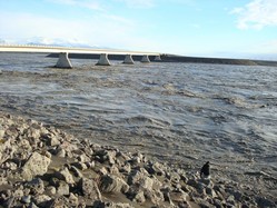
Figure 1. The jökulhlaup from Grímsvötn: image vedur.is
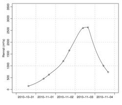
The jökulhlaup (glacial outburst flood) from Grímsvötn that began near the end of October is now coming to an end. The flood reached a maximum level shortly after noon on November 3, and scientists from IMO visited the site on that day to study the effects of the flood on the region adjacent to the ice margin. Two IMO technicians have performed regular discharge measurements on the bridge over the river Gígjukvísl throughout this week (Figure 1) and the results from their measurements are shown in Figure 2.

Figure 2. Discharge (m3/s) measurements at Gígjukvísl bridge: From the curve the total amount of floodwater is estimated 0.45 km3
The discharge curve is typical for jökulhlaups from Grímsvötn that do not result from volcanic activity: Over the course of several days, the amount of water flowing through an ice tunnel at the glacier bed steadily increases. Loss of frictional heat from the floodwater causes melting of the tunnel walls, thereby increasing the flow capacity of the tunnel.
In past centuries, most jökulhlaups from Grímsvötn have entered the course of the river Skeiðará. This time, however, floodwater that emerged from beneath the eastern part of the glacier went westwards along the glacier margin and then entered the river Gígjukvísl. Skeiðará has deposited very large amounts of sediment on the eastern part of Skeiðarársandur plains over the centuries, increasing the elevation of the sandur area there relative to the central part. In addition, the glacier has carved a trench during times of advance. Thus, it was clear that retreat of the glacier over the past 15 years would sooner or later lead to a drastic shift in the direction of meltwater flow from this part of the glacier. In the summer of 2009, this shift occurred and water has ceased to enter the course of Skeiðará.
Tags:Flood, Glacier, Grímsvötn, Iceland, Volcano
Posted in Environment, Iceland, Natural Disasters | Comments Off on Iceland volcano watch stands down
November 6, 2010
Mount Merapi volcano lies 431 km from Jakarta. But the continuing eruptions over the last two weeks have pumped sufficient ash sufficiently high into the atmosphere that flights to Jakarta are beginning to be cancelled. Flights to Yogyakarta, the nearest large airport to Mount Merapi, were suspended a few days ago.
The Guardian reports:
Several airlines have suspended flights into Indonesia’s capital Jakarta after Mount Merapi’s worst eruption in a century spewed volcanic ash up to five miles (8km) into the air.
The move came as number of people killed by Mount Merapi in the last two weeks climbed to 138 after the volcano unleashed a surge of searing gas yesterday that torched houses and trees and incinerated villagers.
Officials at Singapore Airlines, Japan Airlines, Malaysia Airlines, Lufthansa, Cathay Pacific and AirAsia fear the ash is a safety threat and could damage aircraft.
“The volcanic ash presence in the airways surrounding Jakarta could cause severe damage to our aircraft and engines which could impair the safety of our operations including passengers and crew,” said Azharuddin Osman, director of operations for Malaysia Airlines.

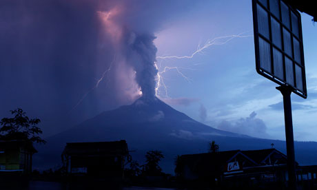
Lightning strikes as Mount Merapi volcano erupted today, spewing out towering clouds of hot gas and debris, as seen from Ketep village in Magelang, Indonesia's Central Java province. Photograph: Beawiharta/Reuters
Tags:ash clouds, flight cancellations, Indonesia, Mount Merapi, Volcano
Posted in Air pollution, Aviation, Environment, Indonesia, Natural Disasters | Comments Off on Mount Merapi ash cloud leads to cancellation of flights to Jakarta
November 5, 2010
AFP reports:

Merapi eruption
ARGOMULYO, Indonesia: At least 49 people were killed and scores injured Friday when Indonesia’s Mount Merapi volcano erupted again, incinerating villages as far as 18 kilometres (11 miles) away, officials said. The latest deaths bring the total toll to more than 90 since the country’s most active volcano started erupting on October 26. Ash, deadly heat clouds and molten debris gushed from the mouth of the 2,914-metre (9,616-foot) mountain and shot high into the sky for most of the night and into the morning.
The ranks of evacuees swelled past 100,000 people, with 30,000 moved into a sports stadium about 25 kilometres away from the peak. “The emergency shelters are now overcrowded,” emergency response field coordinator Widi Sutikno said.
The international airport at Yogyakarta was closed as ash clouds billowed to the altitude of cruising jetliners and the runway was covered in gray soot, officials said. The exclusion zone was widened from 15 to 20 kilometres around the mountain and everyone living in the area was ordered to evacuate their homes and shelters immediately, he said. Indonesia’s transport ministry has told pilots to stay at least 12 kilometres away from the rumbling volcano and several flights linking central Java to Singapore and Malaysia have been cancelled this week.
Government volcanologist Surono said Friday’s blasts were the largest yet.

Mt. Merapi: map credit hobotraveler.com
Tags:Central Java, Indonesia, Mount Merapi, Volcano
Posted in Environment, Geosciences, Indonesia, Natural Disasters | 3 Comments »
November 1, 2010
Reuters:
Meltwater is flooding from the Grimsvotn glacial lake in Iceland and could signal the volcano underneath is about to erupt, a spokeswoman at the Icelandic Civil Protection Department told Reuters on Monday.
Water now pouring from Iceland’s biggest glacier, Vatnajokull, which sits on top of a number of volcanic hotspots, could be a sign of fresh geological activity, Civil Protection Department spokeswoman Gudrun Johannesdottir told Reuters.
In April, clouds of ash from an eruption under the Eyjafjallajokull glacier grounded flights across Europe for a week, causing billions of dollars in losses for airlines and other industries. Eyjafjallajokull is about 100 km southeast of Vatnajokull.
“We have to check if there will be an eruption,” Johannesdottir said. “Sometimes it initiates an eruption when a glacial outburst flood starts, but not every the time. So we are monitoring the situation closely.”
The latest eruption at Grimsvotn, in 2004, caused short-term disruptions to airline traffic into Iceland.

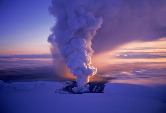
Smoke from a subglacial volcanic eruption rises above the Vatnajökull ice cap (file photo by Oddur Sigurdsson)
Tags:Eyjafjallajökull, Grímsvötn, Iceland, Vatnajökull, Volcano
Posted in Geosciences, Iceland, Volcanoes | 1 Comment »
September 28, 2010
Saudi Arabia’s deserts are not usually associated with volcanic activity but Reuter’s reports that:

Fissures formed in western Saudi Arabia during the earthquake swarm
Magma has worked its way up to just under the surface in a remote region of northwest Saudi Arabia, causing a flurry of small to moderate quakes and threatening to form a new volcano, researchers said Sunday. A swarm of 30,000 quakes shook the region of Harrat Lunayyir from May to June last year and opened an 5-mile long rift, the U.S. Geological Survey team reported.
A wary Saudi government evacuated 40,000 residents at the time but has since let them move back home. But the residents should be ready to leave again if the ground starts to shake, the USGS team reported in the journal Nature Geoscience.
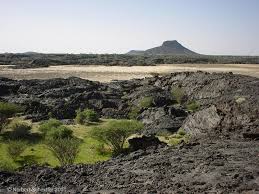
Harrat Lunayyir volcano is located in NW Saudi Arabia
“This finding indicates that the region is at risk from significant geohazards,” John Pallister of the USGS and colleagues at King Abdullah University of Science and Technology in Saudi Arabia and elsewhere wrote. The area is known for its lava fields, called harrat in Arabic, as well as small volcanic cones and volcanic ash called tephra. “The 2009 intrusive episode at Harrat Lunayyir, along with geomorphically young lava and tephra deposits are reminders that, although eruptions are not frequent, the harrat fields remain active and potentially hazardous,” they wrote.
Tags:Harrat Lunayyir, Saudi Arabia, Volcano
Posted in Volcanos | Comments Off on Saudi Arabia vulnerable to volcanoes