Ecstatic Icelandic commentary when their part-time amateurs defeated England’s team of the richest footballers in the world.
Ecstatic Icelandic commentary when their part-time amateurs defeated England’s team of the richest footballers in the world.
It is cool summers – not cold winters – which will be the harbingers of the coming of a little ice age. In the north of Iceland it has been the coldest summer in over 30 years (since 1983) and in the south it has been the coolest since 1992.
The first thirteen weeks of summer this year have been the coldest in Reykjavik in over twenty years, reveals Icelandic meteorologist Trausti Jónsson.
The northern city of Akureyri fares even worse – one has to go back around thirty years to find a colder summer. Last year was Akureyri’s warmest summer in 67 years.
Summer in Reykjavik has not been this cold since 1992, although the summer of 1979 was by far the coldest. The warmest summer in Reykjavik in the past 67 years was in 2010.
Summer in Akureyri has not been this cold since 1983.
And meanwhile the UK summer has been pretty miserable as well:
Paul Homewood: As I indicated a couple of weeks ago, July has been another miserably cold affair, despite a couple of hot days at the start of the month.
The UK as a whole has been 0.7C below the 1981-2010 average, with the west and north particularly cool. In Scotland, it was the coldest July since 1998. This is the third cool month on the trot, making the May to July start to the holiday season the coldest since 1996.
Despite a mild winter and early spring, UK temperatures year to date are now running 0.2C below the 1981-2010 average.
In autumn 1615, Ari Magnússon, Sheriff of Ögur, decided at a meeting in Súðavík that it was free for Icelanders to kill Basque sailors. It resulted in a bloodbath and 32 Basques were killed. Now 400 years later, this provision is formally being revoked.
Basques can now visit Iceland freely without any fear of being lynched on the streets.
Islandsbloggen has the story:
It has been called Iceland’s only mass murder. But after 400 years Basques and Icelanders will now conclude a symbolic peace. At the same time, a small monument will be raised in Hólmavík to honor the memory of the 32 Basque sailors who were killed in autumn 1615 under the leadership of Ari Magnússon, Sheriff of Ögur. Relatives as well as the Minister of Culture Illugi Gunnarsson will attend the ceremony.
As whaling became increasingly important – both for oil and for meat – Basque whalers journeyed far from home to chase their prey. Their travels took them, among other places, to Newfoundland on the east coast of Canada and to Svalbard.
In early 1600 Basque whalers found themselves in Iceland and the Westfjords. However, it was not to become a long-standing tradition. In Autumn 1615, 86 whalers were ready to return home with huge catches loaded aboard three ships. But a sudden storm in Reykjarfjörður in Strandirregionen crushed all their boats. Three sailors died in the storm.
Using a smaller boat they rounded the Hornstrandir to search for ships that could sail home together with their catches. At Dynjandi in Jökulfjörður they stole a bigger boat and captured the former crew.
The news spread like wildfire in the region. Not so very long before, in 1579, pirates had attacked the farm at Rauðisandur in the West Fjords. The attack had led Judge Magnús Jónsson to require all adult Icelanders in the region to bear arms.
He was probably reminded of this fear of the earlier pirates when Ari Magnússon, Sheriff of Ögur, at a meeting in Súðavík decided that it was free to kill the Basque sailors. The Sheriff was in fact a relative of one of the earlier victims, Eggert Hannesson whose home had been looted.
The Basques had made camp at Sandeyri on Snæfjallaströnd. As they were busy with their catches Ari Magnússon went on the attack attack. In all 18 people were killed at Sandeyri and on the island Æðey. The other Basques were killed in Dýrafjörður where they had broken into the Danish trading house in Þingeyri.
In reality, it was a bloodbath. Fifty of the shipwrecked Basques managed to escape to Patreksfjörður. When spring’s first English ship arrived in the fjord, the Basques seized it – and never returned more to Iceland.

District Commissioner Ari Magnusson of Ögur and his wife Kristín Guðbrandsdóttir
The memory of those Basques was commemorated at a ceremony in Hólmavík on April 22nd. A memorial stone with a plaque unveiled in honor of the victims is located outside the Witchcraft Museum. Relatives of both perpetrators and victims were at the ceremony. A ‘symbolic reconcillation’ was acted out by Xabier Irujo, descendant of one of the murdered Basque whale hunters, and Magnús Rafnsson, descendant of one of the murderers.
An account of the events is available here: Spánverjavígin – Slaying of the Spaniards
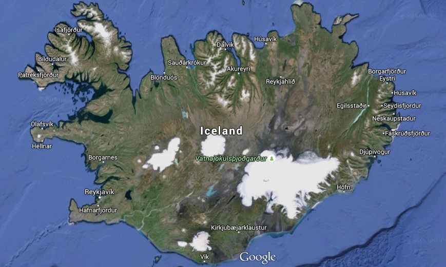
Here in Rejkjavik we heard something about how a country of less than 300,000 became independent in 1944. It has not been easy but my perception is that Iceland has battled its way out of the Great Banking Scandal and Financial Crisis of 2008 and is now back on a tourist driven growth path (even though prices are even higher than I expected).
It is not irrelevant that Iceland has access to such enormous amounts of geothermal energy. It only convinces me even further – if that was possible – that it is access to energy and electricity that is fundamental to humans mastering the global cooling cycle – that is already underway – and the next ice age whenever it comes.
But back to Scotland.
There is no doubt that they could have gone it alone. But I am also glad that there is no change to the world order that I know and the UK that I am familiar with. The Scots will see themselves continuing as part of Britain.
But the English will continue to believe in the supremacy of the English Pound and the Bank of England and the English Queen as being their gifts to Scotland (and the world).
There will always be a Wales!
The fissure eruption continues in Iceland. The length of the lava stream is now about 16.8 km.
I am looking forward to visiting Iceland next week.
On 5th September:

Bardarbunga Photo taken 5th September at 0939 by Olafur Freyr Gíslason.
- The eruptive activity at Holuhraun continues at similar intensity. Lava flows at similar rates as yesterday. The lava is flowing towards East but widens slightly towards North. The main flow follows the river bed of Jökulsá á Fjöllum. No explosive activity due to the lava and river water interaction has been observed, but steam rises from the lava.
- Forecasts indicate that high concentrations of sulphuric gases may be expected in the northern part of the Eastern fjords, Fljótsdalur, Hérað, Jökuldalur, and Vopnafjörður. High concentrations could occur in other areas as well.
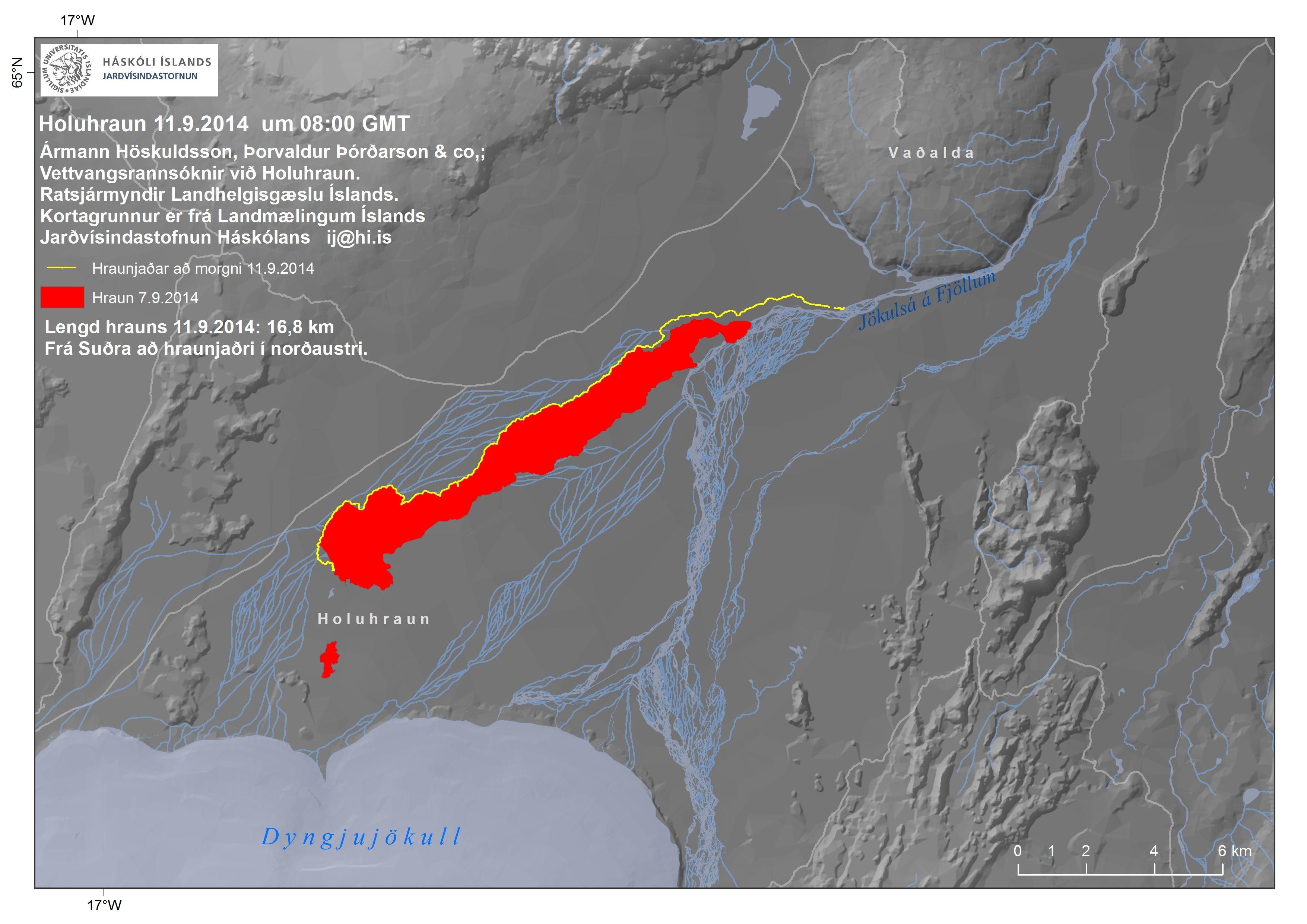
The extent of the lava, Thursday morning. The edge (yellow line) is creeping closer to mountain Vaðalda
A flight over the glacier has discovered a row of 10-15 m deep cauldrons south of the Bárðarbunga caldera. They form a long line. The cauldrons have been formed as a result of melting, possibly sub-glacial eruption, uncertain when. There are three circular crevasse formations, about 5 km in total length. The ice thickness in the area is 400-600 m. No signs of flooding have been detected.
Now a small fissure eruption further north has been detected.
The Aviation Colour Code remains at the ‘orange’ level for Bárðarbunga.
Iceland Met Office reports:
A fissure eruption has started north of Dynjujökull.
29th August 2014 02:45 – An eruption north of Dyngjujökull
An eruption started in Holuhraun north of Dyngjujökull at around 00:02. Seismic tremor was observed on all seismic stations and the web camera installed in the area by Mila has showed some nice pictures of the eruption. It is a small fissure eruption and at 02:40 AM the activity appears to have decreased.
28th August 2014 18:14 – from geoscientist on duty
Since midnight over 1100 earthquakes have been detected by the automatic system. The dyke does not appear to have migrated further north since noon. The main activity is in the dyke and at similar depth as before (8-12km). One earthquake of M5 occurred at 08:13 AM by the northern rim of the Bardarbunga caldera. Two minutes earlier (08:11) another event of M3.9 occurred at a similar location. A few earthquakes were detected near Askja, the biggest one of M2.7.
28th August 2014 12:35 – from of the Scientific Advisory Board
Scientists from the Icelandic Meteorological Office and the Institute of Earth Sciences, together with representatives of the Civil Protection in Iceland, met today to discuss the on-going unrest at the Bárðarbunga volcano.
Conclusions of the Scientific Advisory Board:
- This morning, there was a flight over the Bárðarbunga area and the surface of the glacier was surveyed. No changes to the ice crevasses southeast of Bárðarbunga, that were seen yesterdayevening, were observed. These crevasses were likely formed due to melting at the ice bottom.
- The depressions have been located southeast of the Bárðarbunga caldera, in all likelihood within the water divide of the river Jökulsá á Fjöllum. There are three circular crevasse formations, about 5 km in total length. The ice thickness in the area is 400-600 m.
- The water level in Grímsvötn Lake has been surveyed and has likely risen by about 5-10 m in the last days, which corresponds to an addition of 10-30 million m³ of water in the lake. A slight increase in conductivity in Köldukvísl River was measured this morning, but the cause is yet unknown. No change has been measured in the Hágöngulón lagoon, Jökulsá River and Skjálfandi River. It is assumed, that the water from the cauldron has flowed into the Grímsvötn Lake or the river Jökulsá á Fjöllum.
- The seismic activity is similar to that of the last days. Around midnight, three earthquakes of magnitude around 4 were recorded and one of magnitude 5 at 08:13 this morning, all located within the Bárðarbunga caldera.
- Shortly before 08:00 this morning, there was a slight increase in seismic activity in the Askja volcano. Changes in the stress field due to expansion caused by the dyke have an effect on the Askja area.
- Since yesterday, the length of the dyke under Dyngjujökull has increased by 1-1.5 km to the north, which is considerably less than in the last days. The dyke has now reached the fissure system of the Askja volcano and GPS measurements indicate that the area there is greatly affected.
- The conclusions from the meeting of the Scientific Advisory Board of the Icelandic Civil Protection will continue to be published at around noon, after the meeting, if necessary.
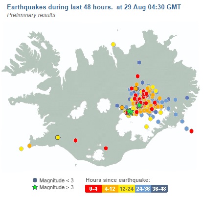
Iceland earthquake swarm 20140829
The Icelandic Met Office has issued the following warning:
It is believed that a small subglacial lava-eruption has begun under the Dyngjujökull glacier. The aviation color code for the Bárðarbunga volcano has been changed from orange to red.
23rd August 2014 17:08 – status report
Overall assessment from the joint daily status report 230814 of the Icelandic Met Office and the University of Iceland, Institute of Earth Sciences:
The aviation color code has been raised to “red” as the data is currently interpreted as a subglacial eruption. Both the thickness of the ice at the possible contact point (100-400 m) and the volume of lava in possible contact with ice are highly uncertain. It could be 0-20 hours before lava reaches the surface of the ice. It is also possible that the lava will not break through the ice, and the eruption could remain subglacial.
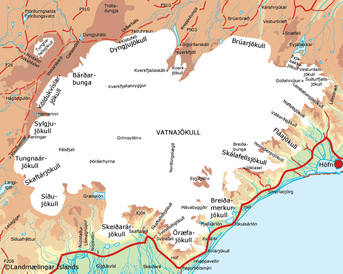
vatnajokull glacier and its volcanoes image wired.com
There is no telling how large or how small this eruption may be. But it has been 23 years (Pinatubo, 1991) since a VEI 5+ volcano eruption somewhere in the world and such an eruption is now “overdue“:
Through the 20th century, an eruption of intensity 5 or greater came at intervals varying from 1 year upto 23 years with an average interval of just under 7 years.
We are due to visit Iceland next month but that may now depend on how this develops.
The Iceland Met Office has upgraded its warning about a potential eruption of Bárðarbunga volcano and said there were “strong indications of ongoing magma movement”.
The intense seismic activity that started on 16 of August at Bárðarbunga persists. Very strong indications of ongoing magma movement, in connection with dyke intrusion, is corroborated by GPS measurements. There are currently two swarms: one to the E of Bárðarbunga caldera and one at the edge of Dyngjujökull just E of Kistufell. At 2.37 am on the 18th a strong earthquake (M4) was located in the Kistufell swarm.
This is the strongest earthquake measured in the region since 1996. As evidence of magma movement shallower than 10 km implies increased potential of a volcanic eruption, the Bárðarbunga aviation color code has been changed to orange. Presently there are no signs of eruption, but it cannot be excluded that the current activity will result in an explosive subglacial eruption, leading to an outburst flood (jökulhlaup) and ash emission.
From Volcano Discovery:
The volcano is hidden beneath the northwestern part of the Vatnajökull glacier, and contains a 700-m-deep caldera that is hidden beneath ice and has extensive flank fissures, from where eruptions have taken place: the Veidivötn fissure extends for over 100 km to the SW, almost reaching Torfajökull volcano, while the Trollagigar fissure extends 50 km to the NE touching Askja volcano.
vatnajokull glacier and its volcanos image wired.com
The summary issued on Monday says that though intense earthquake swarm continues at Barðarbunga further movement of magma towards the surface has not been detected.
Summary written 18th August at 20:45
Since the onset of the earthquake swarm at Bárðarbunga on Saturday morning 16th August 03:00am, around 2.600 earthquakes have been detected with the earthquake monitoring network of the Icelandic Meteorological Office (IMO), of these around 950 since midnight (17/18th August). Several of these events were larger than magnitude 3. The swarm initially started in the Bárðarbunga caldera and has been migrating in two clusters towards the north and the east of the volcano.
On Sunday 17th of August, these two clusters were active east and north of Bárðarbunga. The activity in both clusters was migrating northeastwards. While the strongest events were located in the northern cluster, the highest number of events was detected in the eastern cluster. The strongest event since the onset of the swarm was detected on Monday morning 02:37 in the northern cluster. Detailed analysis revealed that its magnitude was 4.5 and it was felt in Akureyri and Lón. By Monday evening, activity has significantly decreased in the northern cluster.
The eastern cluster remains active. Two stronger pulses of activity have occurred between 10:45 and 12:00 as well as 16:50 and 17:30 this morning. Within the first pulse around noon, the cluster was again migrating northeastwards, most events are now located between Bárðarbunga and Kverkfjöll. As reported earlier, GPS ground deformation data has evidenced that the earthquake swarm is caused by magma intrusion.
Throughout the whole sequence until now (18th August at 20:45) the majority of events has been at 5-10km depth. No signs of migration towards the surface or any other signs of imminent or ongoing volcanic activity have been detected so far. IMO is monitoring the area around the clock very closely and will update in case of any changes.
Something to watch closely over the next few days. Could a new island be forming?
UPDATE2: 04 Apr 18:57 GMT
The aviation colour code for Hekla volcano has been changed from yellow to green as no further signs of unrest have been detected since it was changed to yellow. The activity in North Iceland has been decreasing today. The activity could still continue for a some time with intense activity in between.
UPDATE: A M5.5 earthquake occurred at 00:59 on 2nd April 2013 about 15 km east of Grímsey island offshore North Iceland. The earthquake was felt at Grímsey, Húsavík, Raufarhöfn, Mývatnssveit, Akureyri and Sauðarkrókur. Several hundruds aftershocks have been detected following the mainshock. The source region is located on a fault system that reaching from Öxarfjörður to the north of Grímsey, the so called Grímsey lineament. Another M4.7 earthquake followed this morning at 08:56 and was located about 7.5km northwest of the night’s main event.
Earthquake sequences are common in this area. It is impossible to predict the further development of the seismic activity and how it might influence faults in its vicinity. Further large events can not be excluded.
==========================================
The Iceland earthquake swarm has now reached a count of 482 according to the Icelandic Met Office.
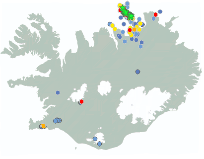
Earthquakes during last 48 hours. at 04 Apr 19:50 GMT
Update 10:49 UTC : We have added a Google Earth screenshot to the image series. This Google earth image shows very clearly the many volcanic bubbles at the ocean floor, a result of the separating diverging plates. The 2 tectonic plates are pullling away from each other (left plate to the West, right plate to the East. This kind of phenomenon is also occurring in the Oceans all over the world. New life (in other words new magma) is added this way to the tectonic plates. The plates are melting away again below ie. the deep trenches of the Pacific Ocean.
Update 10:12 UTC : The Icelandic seismological Bureau wrote : At 00:59 an earthquake about 5.5 occurred, 15 km east of Grímsey. the earthquake was felt in substantial part of central north Iceland. Following the this event at 1:13 another earthquake 4,3 was observed 16 km east of Grímsey and at 08:55 an earthquake 4,7 at same location. Substantial aftershock activity has been observed and still continues. More activity can be expected.
This earthquake is part of a strong swarm at a well know location in the Ocean. The location of the swarm is a relatively shallow ridge area (the zigzagging ridge creates the transform-like earthquakes) . A ridge is a location where 2 tectonic plates are pulling away from each other. Fresh magma will have an easier job to reach the seabed and hot volcanic vents are often found on these locations. A new island in such an area is almost a certainty in the geological future. A pity that there are no permanent ROV’s in this location, we might see some submarine fireworks!
At the time of writing this article, we have counted 314 earthquakes in less than 48 hours!

Swarm area on Google Earth
For the first time in two years the Iceland Meteorological Office has raised the aviation warning code for Mount Hekla from green to yellow due to unusual seismic activity around the volcano. Seven minor seismic events have occurred since 10th March and these are considered abnormal around Hekla. Hekla has erupted 20 times since 874 CE and erupted last in 2000 and previously – in recent times – in 1991, 1981,1980, 1970 and 1947.
The Icelandic Meteorological Officehas changed the aviation colour-code of Hekla volcano from green to yellow, signifying elevated unrest above a known background level during the last weeks. The Icelandic Civil Defence together with the Police in Hvolsvöllur have declared a level of uncertainty for Hekla. The change from green to yellow is a precautionary step due to increased earthquake activity. To date, there are no observable signs that an eruption of Hekla is imminent.

location of iceland volcanos (from decadevolcano.net)

