Archive for the ‘Natural Phenomena’ Category

Weak El Nino conditions but timely monsoon still expected

May 18, 2015

El Nino conditions can suppress the Indian southwest monsoon. Weak El Nino conditions exist for the second year running but the IMD’s forecast is for the monsoon to hit the mainland at Kerala on 30th May ± 4 days.

Whenever an El Nino is about, the doomsayers compete with catastrophe scenarios, but the possibility of a “bad” monsoon in 2015 is diminishing.The economic and industrial recovery should not be adversely affected to any great extent.

Forecasts for the last nine years (2005 to 2014) were as in the table below.

Monsoon onset dates.emf

A timely monsoon (onset during May) does not necessarily mean a “good” monsoon during the official 4 months (June to September) of the season, but does decrease the probability of a “bad” monsoon. The pre-monsoon rains during May have been somewhat higher than normal but not uniformly across the country. Rainfall at the wrong time is not that useful of course but early rainfall in May and late rainfall in October does still have value.

IMD ForecastFor the last about six months, positive SST anomalies have been prevailing over the western and the central Pacific Ocean. However, the SSTs over eastern Pacific after remaining near to below normal between late December 2014 and mid-March 2015 have now become above normal. Thus currently, weak El Nino conditions are prevailing over the Pacific.

The latest forecast from the IMD-IITM coupled model forecast indicates El Nino conditions are likely to persist during the southwest monsoon season.

At present, slight negative Indian Ocean Dipole (IOD) conditions are prevailing over Indian Ocean. The latest forecast from the coupled model indicates negative IOD conditions are likely to persist during the monsoon season. ……. the extreme sea surface temperature conditions over Pacific and Indian Oceans particularly ENSO conditions over Pacific (El Nino or La Nina) are known to have strong influence on the Indian summer monsoon.

 Quantitatively, the monsoon seasonal rainfall is likely to be 93% of the Long Period Average (LPA) with a model error of ± 5%. The LPA of the season rainfall over the country as a whole for the period 1951-2000 is 89 cm.

It is early days yet, but currently the advancing monsoon front is past the Andamans and slightly ahead of the long term average.

Monsoon front May 2015 IMD

Monsoon front May 2015 IMD

NASA “US has not seen landfall of any hurricane of Category 3 or higher for nine years”

May 15, 2015

What exactly is this man-made climate change which is caused by the use of fossil fuels?

It cannot be global warming which has been absent for almost 20 years while the use of fossil fuels has doubled.

“It is stormier weather”, I hear the warmists say.

Well not according to NASA at least for hurricanes. And when NASA can do no better than to reckon that the non-occurrence of hurricanes is a matter of “luck” I have little tolerance for the alarmists and their “religious belief” that every storm which occurs is caused by human influences.

NASA:

Statistical analyses from hurricane track data indicate that for any particular Atlantic Hurricane season, there is about a 40 percent chance that a major hurricane (category 3 or higher) will make landfall in the continental United States. However, during the period from 2006 to 2014, no major hurricanes have made landfall.
NASA’s Goddard Space Flight Center

The United States hasn’t experienced the landfall of a Category 3 or larger hurricane in nine years – a string of years that’s likely to come along only once every 177 years, according to a new NASA study.

The current nine-year “drought” is the longest period of time that has passed without a major hurricane making landfall in the U.S. since reliable records began in 1850, said Timothy Hall, a research scientist who studies hurricanes at NASA’s Goddard Institute for Space Studies, New York.

The National Hurricane Center calls any Category 3 or more intense hurricane a “major” storm. The last major storm to make landfall in the U.S. was Hurricane Wilma on Oct. 16, 2005 – the fourth major storm landfall of that year, which was the most active Atlantic hurricane season on record. Of course, storms smaller than a Category 3 have made landfall with destructive results, such as Hurricane Sandy in 2012.

Hall and colleague Kelly Hereid, who works for ACE Tempest Re, a reinsurance firm based in Connecticut, ran a statistical hurricane model based on a record of Atlantic tropical cyclones from 1950 to 2012 and sea surface temperature data. While hurricane records stretch back to 1850, the data becomes less complete prior to 1950, Hall said. The study was published recently in Geophysical Research Letters.

The researchers ran 1,000 computer simulations of the period from 1950-2012 – in effect simulating 63,000 separate Atlantic hurricane seasons. They found that a nine-year period without a major landfall is likely to occur once every 177 years on average.

While the study did not delve into the meteorological causes behind this lack of major hurricane landfalls, Hall said it appears it is a result of luck.

“The last nine hurricane seasons were not weak – storms just didn’t hit the U.S.,” Hall said. “It seems to be an accident of geography, random good luck.” ….. “Each year is roughly independent of the year before,” Hall said. “There are known signals, and natural cycles, and possibly human-induced influences. But for the most part, they are independent, especially for the rare intense landfalls.”

The Antarctic has more ice cover than has ever been measured before. Global sea ice extent is at its highest levels seen in a decade. Snow cover in the Northern hemisphere are at among the highest levels recorded. So if the 9-year non-occurrence of US hurricanes is only to be expected every 177 years, what exactly is this man-made climate change which is caused by fossil fuels?

The Lorentz effect does not apply to climate, and fossil fuels are not the “flap of a butterfly’s wings” causing climate change.

The butterfly effect

coined by Edward Lorenz, is derived from the metaphorical example of the details of a hurricane (exact time of formation, exact path taken) being influenced by minor perturbations such as the flapping of the wings of a distant butterfly several weeks earlier. Lorenz discovered the effect when he observed that runs of his weather model with initial condition data that was rounded in a seemingly inconsequential manner would fail to reproduce the results of runs with the unrounded initial condition data. A very small change in initial conditions had created a significantly different outcome”.


Help is often restricted by the ability to receive – be it Nepal or Baltimore

April 28, 2015

The news today about the riots and looting currently ongoing in Baltimore got me to wonder why in 2015 such behaviour is still possible in the US? Even with a black (or more accurately, half-black) President and a black Attorney General (Holder followed by Lynch). One hundred and fifty years after the Civil War, and after over 5 decades of “affirmative action”, why are “African Americans” still at the bottom of all social and economic league tables in the US? Why are they – as a group – being overtaken even by the “new immigrants” from Asia?

Could it be that the efforts to lift the African American community have been misguided, or that the particular measures on offer have not been capable of being received?

Take the situation in Nepal.

There is much international help on offer but much is not getting through because of the limitations on the ability (infrastructure and personnel) to receive it. The current death toll of over 4,000 may turn out eventually to be closer to 10,000 .

Planes arriving in Kathmandu have been slow in being unloaded and then the relief supplies have been stuck on the ground because many of the airport workers have left for their own damaged homes and injured relatives. The airport was never designed to handle this level of traffic. The aftershocks are continuing and everything comes to a halt when one occurs.

Relief and medical teams from India and China remained undeployed for many hours because there was nobody available to direct them where to go. And when the “authority” of who would decide was settled, they had no information as to where the teams could be best deployed. Infrastructure was poor in any case but is now damaged. Highways into the remote areas are blocked. Power and water distribution has been hit hard. Foreign teams arriving in Kathmandu have not had the local support necessary readily available. In fact, just finding the necessary support for the foreign teams (guides, interpreters, vehicles, maps, intelligence) itself has overloaded the few organised resources available. The Nepalese Army is overwhelmed. Many Gurkha villages have been hard hit and the primary concern of some of these Gurkha soldiers is to get to their villages and their relatives.

Even in Kathmandu itself – let alone relief and rescue in remote areas – heavy lifting equipment is limited. Even when available they cannot reach “at least 19” areas of the city because of the narrow lanes which have to be negotiated or because of rubble blocking their access.

It is often underestimated or forgotten that the provision of anything (help or education or technology) – once the will to provide is established – is still restricted by the ability to receive.

I am reminded of the struggles we had with “technology transfer” where the will and readiness to transfer technology was often restricted by the ability to receive and absorb technology. I recall that our efforts to open new factories in rural areas were severely limited by the ability of local villagers to absorb the change from working in a field to working in a factory.

The ability to receive trumps the will to give.


Great Himalayan earthquake is still waiting to happen

April 27, 2015

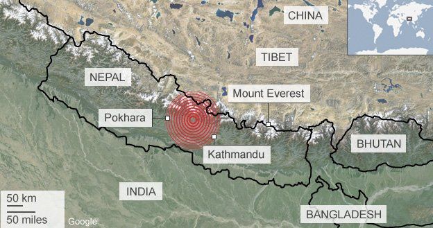
This earthquake in Nepal – devastating as it was – has not released enough of the pent-up strain under the Himalayas. The death toll now exceeds 3,500 and most are due to collapsing buildings.

It would need about 50 such quakes with magnitude 7.9  or one super quake of magnitude 9 to release all the slip built up over centuries. The Indian tectonic plate is being subducted under the Eurasian tectonic plate with the Indian Plate moving North East at about 6 -7 cm per year while the Eurasian Plate is moving Northwards at about 2 cm per year. There is a net 2 – 3 cm of slip to be accumulated – or to be relieved by some form of energy release – every year.

The Great Himalayan Earthquake has still to come. The scale of loss of life and devastation will be magnified greatly if the Great quake is located in the central Himalayas such that the tremors extend into the densely populated Gangetic Plain. The central Himalayas have not seen any large quakes for about 700 years and the pent-up energy is ominous. It is highly unlikely that either in Nepal or in the vulnerable regions of India, that buildings will be sufficiently “earthquake-proofed” to minimise the loss of life (and over 90% of the loss of life is due to the collapse of buildings).

Down to Earth: … It has been hypothesised for long that a large earthquake, called the “great Himalayan earthquake”, can strike anytime, but its time and place cannot be predicted. In many locations in the Himalayan belt there is enough energy stored currently to lead to one.

At a magnitude of 7.9 on the Richter scale, the April 25 earthquake has caused devastation but it is not the anticipated “great Himalayan earthquake”.  This does not qualify as a great earthquake which needs to be of magnitude 8, says Roger Bilham, geologist with the University of Colorado Boulder who studies the seismicity of the Himalayan area. “The earthquake is in a region that is being compressed by18 mm each year,” he says. The amount today’s earthquake slip would have been exactly right to release all this accumulated stress, he adds. His team has identified some areas where the great Himalayan earthquake is anticipated (see image). The question mark shows the area where an earthquake is potentially possible but the magnitude is not known.

himakayan

Anticipated Himalayan Earthquakes

 “This (Nepal earthquake) has unfortunately not come as a surprise. We expected an earthquake of high magnitude in the region between Kathmandu and Pokhara,” says Paul Tapponnier from Nanyang Technological University’s Earth Observatory of Singapore who also studies earthquakes in the area. Tapponnier’s earlier work showed that the quakes in 1255 and 1934 were ground-breaking quakes or when ruptures develop in the earth’s crust and the pent up energy in the earth is released. As the areas west or east of the 1934 Nepal ground rupture do not have records of earthquakes, they are at a greater risk of a major earthquake.

In a paper published just two months ago scientists from the Jawaharlal Nehru Centre for Advanced Scientific Research conclude that “the frontal thrust in central Himalaya may have remained seismically inactive during the last ~700 years. Considering this long elapsed time, a great earthquake may be due in the region”.

The Himalaya has experienced three great earthquakes during the last century—1934 Nepal-Bihar, 1950 Upper Assam, and arguably the 1905 Kangra. Focus here is on the central Himalayan segment between the 1905 and the 1934 ruptures, where previous studies have identified a great earthquake between thirteenth and sixteenth centuries. Historical data suggest damaging earthquakes in A.D. 1255, 1344, 1505, 1803, and 1833, although their sources and magnitudes remain debated. ….. Age data suggest that the last great earthquake in the central Himalaya most likely occurred between A.D. 1259 and 1433. While evidence for this rupture is unmistakable, the stratigraphic clues imply an earlier event, which can most tentatively be placed between A.D. 1050 and 1250. …. Rupture(s) identified in the trench closely correlate with two damaging earthquakes of 1255 and 1344 reported from Nepal. The present study suggests that the frontal thrust in central Himalaya may have remained seismically inactive during the last ~700 years. Considering this long elapsed time, a great earthquake may be due in the region.

Other scientists also estimate that this current quake has dissipated only a very small part of the energy stored under the Himalayas and waiting to be released:

Indian Express:

“We know there is a huge amount of accumulated strain in this area. It is due for a major earthquake, perhaps a series of earthquakes, bigger than 8 on the Richter scale. That is the kind of energy that is estimated to be accumulated there. This was certainly not one of those earthquakes that is probably imminent. In terms of energy release, I would say this would not have released even four or five per cent of the energy that is estimated to be stored there,” said Harsh K Gupta, former director of the Hyderabad-based National Geophysical Research Institute and a former member of the National Disaster Management Authority.

Prof Sankar Kumar Nath of IIT Kharagpur, who has studied seismic activity in the Himalayan region, said the energy released from Saturday’s earthquake “was equivalent to the explosion of about 100mn tonnes of TNT, comparable to the energy in detonation of small nuclear bombs”.

“This earthquake would only be classified as medium in terms of energy released. That area, the 2500-km stretch from the Hindukush region to the end of Arunachal Pradesh, is capable of generating much bigger earthquakes, even nine on Richter scale,” he said.

“If you look at it differently, we are actually lucky that only a 7.9-magnitude earthquake has come. I would be very happy to have a few 7.9-magnitude earthquakes than a 9-magnitude earthquake which would be absolute disaster. The trouble is that in terms of energy release, which is what causes the damage, it would take 40 to 50 earthquakes of magnitude 7.9 to avoid an earthquake of magnitude 9,” he said.

Death toll in Nepal still rising as aftershocks put rescue efforts on hold

April 26, 2015

A strong 6.7 magnitude aftershock hit Nepal this morning, 25 hours after the primary quake, as the death toll continues to climb. At least 30 shocks of magnitude greater than 4.0 have been felt. Kathmandu airport which was open has been closed till 4pm local time because of the aftershocks. Rescue efforts have been put on hold while the aftershocks continue. Air Traffic Control staff have been evacuated from the airport for now.

Indian Air Force Mi-17 helicopters reached Mount Everest and began ferrying injured back to Kathmandu with the first relief flights reaching this morning. So far the IAF has deployed 5 helicopters and another 6 are on their way. It is feared that 65 mountaineers on Mt. Everest may have been killed at the base camp and in the avalanche yesterday. The aftershocks have caused at least 3 further avalanches on Everest today.

Tremors from the aftershocks have been felt in Delhi, UP, Bihar, W.Bengal, and Assam. The final toll may exceed 2,000 as rescuers reach more remote regions.

USGS:

  1. Aftershock: 6.7 magnitude, 17km S of Kodari, Nepal2015-04-26,  07:09:08 UTC, 10.0 km deep
  2. Secondary quake: 6.6 magnitude, 49km E of Lamjung, Nepal2015-04-25, 06:45:21 UTC, 14.6 km deep
  3. Primary quake: 7.8 magnitude, 34km ESE of Lamjung, Nepal, 2015-04-25, 06:11:26 UTC, 15.0 km deep

Both India and China see Nepal as being within their natural “sphere of influence” and a hint of that competition is visible as the two countries now lead the international rescue efforts. In addition to a Chinese medical team that was already in Nepal, three further medical teams from neighboring Sichuan, Chongqing and Yunnan have gone to Tibet.

Xinhua:A 62-strong China International Search & Rescue Team left for Nepal early Sunday. With six sniffer dogs and relevant rescue and medical equipment, the team is expected to arrive in Kathmandu midday Sunday on a chartered plane, according to the China Earthquake Administration.

India sent two relief planes of air force to disaster-struck zones hours after the quake took place. Indian Prime Minister Narendra Modi called up his Nepalese counterpart Sushil Koirala, and assured him of all help. Two military aircraft, a C-130 Hercules and a C17 Globemaster, took off from the Hindon air base in Delhi to Kathmandu with relief workers, medicines and blankets, said Press Trust of India.

Disaster teams from the UK, US and Israel are already on their way as well and many other countries have offered assistance.

Nepal earthquake toll near 1500 with casualties also in India and Tibet

April 25, 2015

The Indian Tectonic Plate is being subducted under the Eurasian Plate. The collision is still going on with the Indian Plate moving North East at about 6 -7 cm per year while the Eurasian Plate is moving Northwards at about 2 cm per year. The subduction occurs in fits and starts and relies on earthquakes to release the slip pressure. The likelihood of a single Himalayan earthquake of magnitude 8 or a series of magnitude 7 quakes was discussed a few years ago

If a great earthquake has not occurred on a specific segment in the Himalaya for 200 years, that segment will slip 4m because the convergence rate between India and Tibet is roughly 2cm each year. If it has not occurred for 500 years the segment would slip 10m, enough for an event that would measure 8, or Magnitude Eight on the Richter Scale. The time interval between great earthquakes thus determines the amount of slip that will occur in the next one.

…. A large segment of the Himalaya between Kathmandu and Dehradun has a record of several earthquakes but only two large ones: an event in 1803 and another in 1833. If these were great earthquakes then there is now roughly 3m of slip ready to go. However, if they were magnitude 7 earthquakes, then there may be more than 20m of slips availabIe for a future great earthquake.

Nepal earthquake map

graphic: BBC

It would seem that this earthquake near Kathmandu was a large one (7.8 magnitude) and may have released around 5 – 8 m of slip but as has been pointed out there may be a total of around 20m of slip waiting to occur. The current quake has so far seen some 16 aftershocks of magnitude 4.5 or greater. Deaths in India are over 40 and the Indian government is mounting a large rescue effort in support of the Nepali government, “Fifty doctors have arrived from India to provide emergency services. India dispatched as many as four aircraft including a C-130 plane carrying three tonnes of relief supplies and a 40-member rescue team to Nepal.” Three more planes are to follow carrying a mobile hospital and medical supplies.

FirstPost: The quake measuring 7.9 on Richter scale, which was followed by 16 aftershocks of magnitude 4.5 or greater, striking heavy casualties in Kathmandu and injuring thousand others. Hundreds were feared missing across the country. “Army estimates death toll as much as 1457 so far,” Nepal’s Finance Minister Ram Sharan Mahat tweeted. …….

The earthquake around 11:56 am with epicentre at Lamjung, around 80 kilometers northwest of Kathmandu, had its impact in several cities in Bihar, West Bengal and Uttar Pradesh and tremors were felt across vast stretches of east and North East India. It was also felt in Southern and Western parts of India, China, Bhutan and as far as Pakistan and Bangladesh.

The US Geological Survey reports:

The April 25, 2015 M 7.8 Nepal earthquake occurred as the result of thrust faulting on or near the main frontal thrust between the subducting India plate and the overriding Eurasia plate to the north. At the location of this earthquake, approximately 80 km to the northwest of the Nepalese capital of Kathmandu, the India plate is converging with Eurasia at a rate of 45 mm/yr towards the north-northeast, driving the uplift of the Himalayan mountain range. The preliminary location, size and focal mechanism of the April 25 earthquake are consistent with its occurrence on the main subduction thrust interface between the India and Eurasia plates.

Although a major plate boundary with a history of large-to-great sized earthquakes, large earthquakes on the Himalayan thrust are rare in the documented historical era. Just four events of M6 or larger have occurred within 250 km of the April 25, 2015 earthquake over the past century. One, a M 6.9 earthquake in August 1988, 240 km to the southeast of the April 25 event, caused close to 1500 fatalities. The largest, an M 8.0 event known as the 1934 Nepal-Bihar earthquake, occurred in a similar location to the 1988 event. It severely damaged Kathmandu, and is thought to have caused around 10,600 fatalities.

Was this the big earthquake that was predicted in the Himalayas?

In an interview to The Hindu in May 2013, Vinod Kumar Gaur, seismologist with the Centre for Mathematical Modelling and Computer Simulation, had said: “Calculations show that there is sufficient accumulated energy [in the MFT], now to produce an 8 magnitude earthquake. I cannot say when. It may not happen tomorrow, but it could possibly happen sometime this century, or wait longer to produce a much larger one.”

In a study published in the journal Nature Geoscience in December 2012, a research team led by Nanyang Technological University (NTU) discovered that massive earthquakes in the range of 8 to 8.5 magnitudes on the Richter scale had left clear ground scars in the central Himalayas

High resolution imagery and dating techniques showed that in 1255 and 1934, two great earthquakes ruptured the surface of the Earth in the Himalayas. The 1934 earthquake broke the surface over a length of more than 150 km.

Probability of a VEI 5+ volcanic eruption within 5 years is over 95%

April 16, 2015

It has been 24 years since the last VEI 5+ (Mount Pinatubo, 1991, VEI 6) occurred and the probability that a VEI 5+ volcanic eruption will occur within the next 5 years is now over 95%. There are around 10 – 14 VEI 5+ eruptions every hundred years and for the the last 300 years the time between eruptions has been as short as 1 year and as long as 23 years. The current gap could be the longest recorded in three centuries. There are, on average, 2 eruptions of intensity 6 every hundred years and so the probability that an eruption of VEI 6 could occur within 5 years is about 50% (current gap 24 years, average gap 50 years). That a supervolcanic eruption of VEI 7 or greater could occur within the next 5 years is less than 1%.

The next VEI 5+ volcanic eruption is overdue During the 19th century VEI eruptions of 5 or greater occurred every 11 years on average with the Krakatoa eruption being the greatest at VEI 6 in 1883. Through the 20th century, an eruption of intensity 5 or greater came at intervals varying from 1 year upto 23 years with an average interval of just under 7 years. The Novarupta (1912) and Mount Pinatubo (1991) eruptions were the two classified at VEI6. 

  • 1902 Santa Maria
  • 1907 Kudach
  • 1912 Novarupta
  • 1913 Colima
  • 1918 Katla
  • 1932 Cerro Azul
  • 1933 Kharimkotan
  • 1956 Bezymianny
  • 1963 Mount Agung
  • 1980 Mount St. Helens
  • 1982 El Chichón
  • 1991 Mount Pinatubo
  • 1991 Mount Hudson
vei eruption balls image geology.com

vei eruption balls image geology.com

So far in this century the 2010 Eyjafjallajökull eruption in Iceland “only” reached a VEI intensity of 4. The Puyehue-Cordón Caulle eruption in 2011 was judged – by some – to be of intensity 5 was really just a VEI 4. The 2012 Mt. Etna eruption was rated a 3+.

Classification of eruptions esf.org

Classification of eruptions esf.org

The impact of the next eruption has to be assessed in a short and a long-term perspective. Immediate loss of life and property is primarily a function of population in the area of the eruption and the time available for evacuation. Populations are higher now than ever in the past but warnings come earlier and possibilities for evacuation are better than ever before.  The population directly at risk from volcanoes in the year 2000 has been estimated at 500 million or more, The long-term impacts could be much more profound and independent of the location of the eruption. We are already into an ocean- current led global cooling cycle. We could well have another year or two without a summer after the next VEI 5+ eruption. The key will be the extent of the dust cloud, the altitude it reaches and for how long it persists. It will not be a Toba like cataclysm which affected the evolution of humans, but it may well be the impulse which drives the earth into an Ice Age. It could even be the start of a 1000 years of transition back into a Glacial Age since the current Interglacial has been around for some 15,000 years.

Extreme Geohazards: Reducing the Disaster Risk and Increasing Resilience VEI values have been determined for more than 5,000 eruptions in the Holocene…. None of these reached the maximum VEI of 8. Several of the most devastating eruptions during the last 2,000 years had VEI values lower than 6. For example, the VEI 5 eruption of Vesuvius in 79 AD destroyed Pompeii and Herculaneum. Since 1500, more than 20 eruptions of VEI 5 or more occurred, with only the Tambora eruption in 1815 reaching VEI 7. It is worth noting that the extremely disruptive eruption of Eyjafjallajökull only reached an estimated VEI of between 3 and 4. …… The size and magnitude of …. the eruption, is only loosely related to the resulting damage. For example, mudflows triggered by the VEI 3 eruption of Nevado del Ruiz (Colombia) in 1985 caused one of the worst volcanic disaster in the 20th century. …… of the nine greatest volcanic disasters in terms of casualties since 1500, only three (Tambora, Krakatau and Laki) qualify as ‘very large’ eruptions with a VEI of greater than 5. ….. during the past 36 Ma, 42 VEI 8 eruptions have been identified. The authors indicate that these eruptions are not evenly distributed in time but seem to cluster in two pulses over the past 36 Ma. Periods with as many as 22 events/Ma and down to 1.4 event/Ma have been identified. More recent examples are the eruptions of Taupo (around 24,000 BC), Toba (around 74,000 BC), and Yellowstone (around 640,000 BC), for which the impacts have been studied in detail. More recent large eruptions with a VEI of 5, 6 or 7 include Thera (≈1630 BC), Vesuvius (79 AD), Laki (1783), Tambora (1815), Krakatau (1883), Novarupta (1912) and Pinatubo (1991). Each of these eruptions (except Novarupta, due to the remoteness of the area) generated immediate loss of life and structures at local distances (through the generation of pyroclastic flows, ash and gas emissions, tsunamis) as well as long-term losses at regional and global distances. These eruptions impacted the climate for long periods by injecting ash in the stratosphere at high altitudes (Tambora’s ash column height reached 43 km) and triggering temperature changes which heavily impacted the harvest and led to famine and epidemics in several areas of the planet: the year 1816, following Tambora’s eruption, is recalled as ‘the year without summer’, and generated abnormal temperatures in China, Europe and North America. 

The hypotheses about man made global warming are neither predictable or measurable and are just fancies. But volcanic eruptions are neither fanciful nor amenable to prediction. They will occur and we have no means of preventing them. Within 5 years it is close to a certainty (> 95%) that a VEI 5+ volcanic eruption will occur. With global mobilisation loss of life can be minimised but the effects of the eruption on climate will just have to be endured.

A total eclipse of the Sun – 20th March, 2015

March 12, 2015

Though it’s a total eclipse only over Svalbard and the Faeroe Islands, it should be a partial but almost complete solar eclipse visible from Scandinavia on Friday March 20th. It should be visible in Europe, northern and eastern Asia and northern and western Africa. The eclipse starts at 07:41 UTC and ends at 11:50 UTC (0841 – 1250 CET).

The red zones will see a complete eclipse and the orange area will see more than 90% of Sun eclipsed by the moon.

total solar eclipse 20th march 2015 time and date.com

total solar eclipse 20th march 2015 timeanddate.com

The monkey orchid

March 8, 2015

Seen at Kuriositas

Dracula simia: These wonderful orchids come from the south-eastern Ecuadorian and Peruvian cloud forests from elevations of 1000 to 2000 meters


Lava flow continues from fissure eruption near Bárðarbunga

September 12, 2014

The fissure eruption continues in Iceland. The length of the lava stream is now about 16.8 km.

I am looking forward to visiting Iceland next week.

On 5th September:

Bardarbunga Photo taken 5th September at 0939 by Olafur Freyr Gíslason.

Bardarbunga Photo taken 5th September at 0939 by Olafur Freyr Gíslason.

  • The eruptive activity at Holuhraun continues at similar intensity. Lava flows at similar rates as yesterday. The lava is flowing towards East but widens slightly towards North. The main flow follows the river bed of Jökulsá á Fjöllum. No explosive activity due to the lava and river water interaction has been observed, but steam rises from the lava.
  • Forecasts indicate that high concentrations of sulphuric gases may be expected in the northern part of the Eastern fjords, Fljótsdalur, Hérað, Jökuldalur, and Vopnafjörður. High concentrations could occur in other areas as well.
The extent of the lava, Thursday morning. The edge (yellow line) is creeping closer to mountain Vaðalda

The extent of the lava, Thursday morning. The edge (yellow line) is creeping closer to mountain Vaðalda