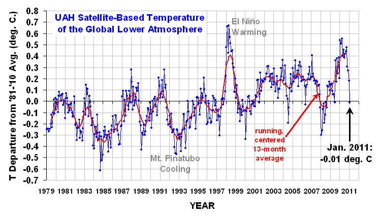
Archive for the ‘Geosciences’ Category

Sun goes quiet again but proton events and heightened risk of earthquake and volcanic activity continues

June 14, 2011

After picking up somewhat in April, the sun has quietened again in May.

Sunspots:

Sunspot numbers

 Radio Flux:

10.7 Radio flux

And,

Astronomers will unveil a “major result” on Tuesday (June 14) regarding the sun’s 11-year sunspot cycle.

The announcement will be made at a solar physics conference in New Mexico, according to an alert released today (June 10) by the American Astronomical Society. The discussion will begin at 1 p.m. EDT (1700 GMT).

In the meantime, 

solar flares and proton events continue signifying a period of heightened volcanic and earthquake activity ——

Piers Corbyn predicts,

 M6+ Earthquakes Indonesia and New Zealand confirm WeatherAction 13-15th June quake risk trial warning.

Two major Earthquakes 13 June M6.0 New Zealand (precede by an M5.5) andM6.4 Molucca Sea Indonesia confirm WeatherAction’s warning issued 22 May for 13-15 June as a period of increased earthquake risk. SEE:

http://www.mauritiushot.com/christchurch-earthquake-13-june/ Two quakes hit Christchurch NZ. http://earthquake.usgs.gov/earthquakes/recenteqsww/Quakes/quakes_big.php

“This 13-15th period”, said Piers Corbyn of WeatherAction.com, “is at the ‘q’ (lesser) level of our now two level forecasts of increased Earthquake risk (trial) around the world compared with other times before and after.  In the upper, ‘Q’, level we expect the biggest increases in seismic activity which also includes notable volcanic eruptions. The last Q period May 31- Jun5th was dramatically marked by the new eruption of the Chile earthquake chain on June 4th as well as associated very extreme weather events”. See http://bit.ly/lFXtsu

The next increased Quake risk period 16-19 June – at the larger, Q, level – follows straight after this one.


Massive 7.4 quake again in Japan – as predicted on 5th April

April 7, 2011

On 5th April there was a large coronal mass ejection on the sun:

article image

The sun on April 5th 2011

In consequence:
– solar wind speed went up
– a 5MeV proton burst and
– proton flux went up.

Piers Corbyn then predicted that heightened earthquake activity was likely between the 6th and 9th of April.

article image

Prediction on 5th April

And lo and behold, a 7.4 magnitude quake has struck off the north east coast of Japan again – strong enough for the Fukushima nuclear plant to be evacuated and for a tsunami warning to be issued. Fortunately no significant damage has been reported and the tsunami warning has now been withdrawn.

Earlier in the day there was  a 6.5 magnitude quake near Vera Cruz Mexico. There are some reports also of increased seismic activity in the western US.

One more piece of evidence linking heightened earthquake and volcanic activity on earth with what happens on the sun.

Related:

Solar effects will give increased volcanic and earthquake activity in the next 2 years

Two 7.0 quakes hit Burma — as predicted?


Solar effects will give increased volcanic and earthquake activity in the next 2 years

February 22, 2011

Solar effects are much more profound than many so-called climate scientists like to admit. It seems entirely plausible to me that earthquakes and volcanism are connected to solar events. This paper by Zhang from 1998 also associates increased Earthquakes with general increases in solar proton events.

http://www.springerlink.com/content/buvw2tq081013210/fulltext.pdf?page=1

Relationship between global seismicity and solar activities

Gui-Qing ZHANG

Vol. 11 No.4 (495~500)  ACTA SEISMOLOGICA SINICA  July, 1998

Beijing Astronomical Observatory, Chinese Academy of  Sciences, Beijing 100101, China

Abstract :

The  relations  between  sunspot  numbers and earthquakes  (M>6), solar 10.7cm  radio flux  and  earthquakes,  solar  proton events and earthquakes have been  analyzed in this  paper. It has been found that:

  1. Earthquakes occur frequently around the minimum years  of  solar activity. Generally, the  earthquake  activities are  relatively less during the peak value years of  solar activity, some  say, a round the period when magnetic polarity  in the  solar polar regions  is reversed.
  2. The earthquake frequency in the minimum period of  solar activity is closely related to the  maximum annual means of sunspot numbers, the maximum annual means of solar 10.7 cm radio flux and solar proton events of a whole solar cycle, and the relation between earthquake and solar proton events is closer than others.
  3. As judged by above interrelationship, the period from 1995 to 1997 will be the years while earthquake activities are frequent. In the paper, the simple physical discussion has been carried out.

Piers Corbyn at WeatherAction comments:

“We now think that it is not just general solar proton event levels which point towards more earthquakes but that individual solar proton events exacerbate immediate earthquake (and associated volcanism) risk either directly or due to consequent storm activity and related surface pressure changes such as caused by our solar triggered and predicted Tropical Cyclone Atu which is currently centred North of New Zealand and heading closer.

There are also additional lunar effects on storm development and earthquakes & volcanism and for solar drivers it appears that the odd-even minima, particularly the later part i.e. the rising phase of even solar cycles – WHICH IS WHERE WE ARE NOW (early Solar Cycle 24) – are the most dangerous.

Prediction of individual Earthquakes is very hard but we are very confident of a continuing period of significantly enhanced earthquake and volcanic activity as well as extreme weather events for the coming one or two years, probably exceeding the levels of the most active extended periods in at least the last 100 years.”

Do super storms indicate that earth’s magnetic polarity is about to switch?

February 8, 2011


geomagnetic reversal is a change in the orientation of Earth’s magnetic field such that the positions of magnetic north and magnetic south become interchanged. These events often involve an extended decline in field strength followed by a rapid recovery after the new orientation has been established. These events occur on a scale of tens of thousands of years or longer, with the latest one (the Brunhes–Matuyama reversal) occurring 780,000 years ago.

On average geomagnetic reversals occur about every 500,000 years so it would seem that a reversal is overdue. How long a reversal takes and whether a reversal can happen very rapidly is not known. That the earth’s geomagnetic field is due to the flow of liquid metals in the earth’s interior – the dynamo theory – is also very likely. The sun’s magnetic reversals seem to happen at every sunspot maximum with an average period of 11 years between reversals giving a 22 year magnetic cycle.

The movement of Earth's north magnetic pole across the Canadian arctic, 1831-2001. Credit: Geological Survey of Canada.

The movement of Earth's north magnetic pole across the Canadian arctic, 1831--2001. Credit: Geological Survey of Canada.

The position of the magnetic poles is also continuously changing with a current drift (increasing) of the magnetic North Pole from N. Canada towards Siberia at about 40km /year. But this movement may be in some cyclic fashion and is unlikely to be directly connected to the half-million year reversals. For the last 200 years the strength of the earth’s magnetic field has been decreasing and could be the precursor of the overdue reversal.

How the earth will behave during a magnetic reversal is a known unknown and provides the basis of much speculation and cataclysmic theories which cannot be tested. The cataclysmic pole shift hypothesis is one such theory which predicts that the earth’s rotation will reverse, the magnetic field will reverse and mankind will be obliterated – probably in 2012!!

But it is thought that reversals take a few thousand years to complete, and during that time–contrary to popular belief–the magnetic field does not vanish.  Magnetic lines of force near Earth’s surface become twisted and tangled, and magnetic poles pop up in unaccustomed places. A south magnetic pole might emerge over Africa, for instance, or a north pole over Tahiti. Weird. But it’s still a planetary magnetic field, and it still protects us from space radiation and solar storms.

Terrence Aym suggests that we may be seeing the beginning of a reversal (and of course since this is overdue it may well occur at any time):

Forget about global warming—man-made or natural—what drives planetary weather patterns is the climate and what drives the climate is the sun’s magnetosphere and its electromagnetic interaction with a planet’s own magnetic field.

File:Magnetosphere rendition.jpg

Artist's rendition of Earth's magnetosphere: NASA via Wikipedia

Magnetic polar shifts have occurred many times in Earth’s history. It’s happening again now to every planet in the solar system including Earth. The magnetic field drives weather to a significant degree and when that field starts migrating super storms start erupting.

The superstorms have arrived.

The Earth’s northern magnetic pole was moving towards Russia at a rate of about five miles annually. That progression to the East had been happening for decades.

Suddenly, in the past decade the rate sped up. Now the magnetic pole is shifting East at a rate of 40 miles annually, an increase of 800 percent. And it continues to accelerate.

Recently, as the magnetic field fluctuates, NASA has discovered “cracks” in it. This is worrisome as it significantly affects the ionosphere, troposphere wind patterns, and atmospheric moisture. All three things have an effect on the weather.

Worse, what shields the planet from cancer-causing radiation is the magnetic field. It acts as a shield deflecting harmful ultra-violet, X-rays and other life-threatening radiation from bathing the surface of the Earth. With the field weakening and cracks emerging, the death rate from cancer could skyrocket and mutations of DNA can become rampant.

Another federal agency, NOAA, issued a report caused a flurry of panic when they predicted that mammoth superstorms in the future could wipe out most of California. The NOAA scientists said it’s a plausible scenario and would be driven by an “atmospheric river” moving water at the same rate as 50 Mississippi rivers flowing into the Gulf of Mexico……

According to some geologists and scientists, we have left the last interglacial period behind us. Those periods are lengths of time—about 11,500 years—between major Ice Ages. One of the most stunning signs of the approaching Ice Age is what’s happened to the world’s precessional wobble. The Earth’s wobble has stopped. ..

….So, the start of a new Ice Age is marked by a magnetic pole reversal, increased volcanic activity, larger and more frequent earthquakes, tsunamis, colder winters, superstorms and the halting of the Chandler wobble.

Unfortunately, all of those conditions are being met.

Read original article


La Niña will last well into 2011 and could extend into 2012

February 5, 2011

A new article has been posted on the National Oceanic & Atmospheric Administration website and comes to the conclusion that there is an even chance that La Niña conditions could extend into 2012:

Multivariate ENSO Index (MEI) by Klaus Wolter 4th February 2011

El Niño/Southern Oscillation (ENSO) is the most important coupled ocean-atmosphere phenomenon to cause global climate variability on interannual time scales. Here we attempt to monitor ENSO by basing the Multivariate ENSO Index (MEI) on the six main observed variables over the tropical Pacific. These six variables are: sea-level pressure (P), zonal (U) and meridional (V) components of the surface wind, sea surface temperature (S), surface air temperature (A), and total cloudiness fraction of the sky (C). …… Negative values of the MEI represent the cold ENSO phase, a.k.a.La Niña, while positive MEI values represent the warm ENSO phase (El Niño)………

Discussion and comparison of recent conditions with historic La Niña events

In the context of the rapid transition of the MEI into strong La Niña conditions, this section features a comparison figure with strong La Niña events that all reached at least minus one standard deviations by June-July, and a peak of at least -1.4 sigma over the course of an event. The most recent moderate La Niña events of 1998-2001 and 2007-09 did not qualify, since they either did not reach the required peak anomaly (the first one) or became strong too late in the calendar year (both).

The updated (December-January) MEI value has strengthened slightly to -1.62 standard deviations after almost dropping below -2 standard deviations in August-September. Nevertheless, the most recent value ranks 2nd for this time of year, clearly below the 10%-tile threshold for strong La Niña MEI rankings , but slightly weaker than the value recorded in 1974. If one were to take the average of all MEI rankings since July-August (a six-month period), the strongest La Niña half-year periods of mid-55, ’73-74, and late ’75 averaged slightly stronger than the current event, for now (this is means Rank 4 for the current event, up one from last month).
Negative SST anomalies are covering much of the eastern (sub-)tropical Pacific in the latest weekly SST map. Many of these anomalies are in excess of -1C.
For an alternate interpretation of the current situation, I highly recommend reading the latest NOAA ENSO Advisory which represents the official and most recent Climate Prediction Center opinion on this subject. In its latest update (6 January 2011), La Niña conditions are expected to last “well” into the Northern Hemisphere spring of 2011. …….. While La Niña conditions are guaranteed well into 2011, it remains to be seen whether it can rally once more to cross the -2 sigma barrier, and/or whether it will indeed last into 2012, as discussed six months ago on this page. I believe the odds for a two-year event remain well above 50%, made even more likely by the continued unabated strength in various ENSO indices.

It seems self-evident ( even if not fashionable or politically correct) that the sun controls our climate and that the oceans do the sun’s bidding as they drive the atmosphere which then determines our weather.

The consequences of an extended La Niña into 2011 / 2012 could be

  • another good monsoon year in India,
  • a cold winter again for 2011/2012 in the Northern hemishere


La Niña begins to show up in global temperature

February 3, 2011

From Dr. Roy Spencer:

credit:drroyspencer.com

…although this, too, shall pass, when La Nina goes away.

January 2011 experienced a precipitous drop in lower tropospheric temperatures over the tropics, Northern Hemisphere, and Southern Hemisphere. This was not unexpected, since global average sea surface temperatures have been falling for many months, with a head start as is usually the case with La Nina.

This is shown in the following plot (note the shorter period of record, and different zero-baseline):

credit:drroyspencer.com

Read original report: http://www.drroyspencer.com/2011/02/uah-update-for-january-2011-global-temperatures-in-freefall/

And Mount Kirishima in Japan is also spewing ash

January 28, 2011

The Japan Times:

News photo

Mount Kirishima's Shinmoedake peak, seen from Takaharu, Miyazaki Prefecture, spews ash Thursday morning. KYODO PHOTO

Mount Kirishima continued erupting Thursday on the border between Kagoshima and Miyazaki prefectures, spewing columns of smoke up to more than 2,500 meters, the weather agency said.

Rocks were blasted as far as 8 km from Kirishima’s Shinmoedake peak, according to the Meteorological Agency. Volcanic ash disrupted train and flight services in the area. The agency revised the scale of the eruption upward to “medium” from the initial “small,” after the smoke columns reached about 500 meters higher than Wednesday. …. Volcanic tremors indicating magma activities also continued Thursday.

The first in-depth eruption began Wednesday at around 7:30 p.m., when the 1,421-meter Shinmoedake peak began spewing debris in its second outburst since a small eruption Jan. 19, the agency said. According to the Miyazaki Observatory, ash is falling on a wide area that includes the cities of Miyazaki and Nichinan in Miyazaki Prefecture, and has partially closed expressways in Kyushu.

According to Bloomberg:

Japan’s government issued alerts after a volcano on the southern island of Kyushu erupted for the first time in 52 years, causing the evacuation of homes and cancellation of more than 60 flights.

Shinmoedake, in the Kirishima range, erupted yesterday, spewing ash as high as 2,500 meters (8,200 feet) into the air, Japan’s Meteorological Agency said in a statement on its website. A second eruption occurred today at about 1 p.m. local time, national broadcaster NHK reported. Ash from the volcano reached Miyazaki city, 50 kilometers (30 miles) to the east, according to the broadcaster.

Japan Airlines Corp. canceled 37 flights to or from nearby Miyazaki airport, according to its website today. Three additional flights will be scrapped tomorrow, it said. All Nippon Airways Co., Asia’s largest listed carrier, canceled 24 flights affecting 3,350 people, spokeswoman Nana Kon said by phone today.

Mount Bromo in the Tengger Caldera ejects ash cloud – disrupts Bali flights

January 28, 2011

From AFP:

JAKARTA — Several international flights to and from the resort island of Bali were cancelled or diverted Thursday to avoid dangerous ash spewing from an Indonesian volcano, officials said.

Ash from rumbling Mount Bromo, a popular attraction in East Java province, had spread to the island popular with foreign tourists and surfers.

“We received information from Darwin that the ash from Bromo has reached 18,000 feet (5,500 metres) in the southeast direction and has affected some parts of Bali,” transport ministry spokesman Bambang Ervan told AFP.

Mount Bromo (Indonesian: Gunung Bromo), is an active volcano and part of the Tengger massif, in East Java,Indonesia. At 2,329 metres (7,641 ft) it is not the highest peak of the massif, but is the most well known. The volcano belongs to the Bromo Tengger Semeru National Park. The name of Bromo is derived from the Javanese pronunciation of Brahma, the Hindu god of creation.

File:Mtbromo.jpg

The Tengger massif in Java at sunrise, showing the volcanoes Mt. Bromo (large foreground crater, smoking) and Mt. Semeru (background, smoking) : Wikipedia

In recent times Mt. Bromo erupted in 2004 (2 deaths) and also in November 2010 when Mt. Merapi was erupting.

Last week saw eruptions also from Anak Krakatau. Anak Krakatau has grown at an average rate of five inches (13 cm) per week since the 1950s. This equates to an average growth of 6.8 metres per year. The island is still active, with its most recent eruptive episode having begun in 1994.

New study confirms Himalayan glaciers will not disappear any time soon

January 24, 2011
This NASA image shows the formation of numerou...

Glacial lakes, Bhutan: Image via Wikipedia

Reuters reports:

(Reuters) – Some Himalayan glaciers are advancing despite an overall retreat, according to a study on Sunday that is a step toward understanding how climate change affects vital river flows from China to India.

“Our study shows there is no uniform response of Himalayan glaciers to climate change and highlights the importance of debris cover,” scientists at universities in Germany and the United States wrote in the study of 286 glaciers.

The findings underscore that experts in the U.N.’s Intergovernmental Panel on Climate Change (IPCC) were wrong to say in a 2007 report that Himalayan glaciers could vanish by 2035 in a headlong thaw. The panel corrected the error in 2010.

The report said that 58 percent of glaciers examined in the westerly Karakoram range of the Himalayas were stable or advancing, perhaps because they were influenced by cool westerly winds than the monsoon from the Indian Ocean.

Science News says:

Glaciers largely stable in one range of Himalayas

Dirk Scherler of the University of Potsdam, Germany, and his colleagues report in the January 23 Nature Geoscience. ……. but in Karakoram, 58 percent of studied glaciers were stable or slowly expanding up to 12 meters per year…..

The new findings are consistent with what Kenneth Hewitt of Wilfrid Laurier University in Waterloo, Ontario, has observed, and point to the fact “that the picture of climate change effects in high Asia is much more complicated than most people realize.”

Indeed, for much of the past century Karakoram’s glaciers were in retreat. A 2005 paper by Hewitt described a turnaround that commenced only in the late 1990s. In the new study, Scherler’s team looked for factors that might affect the responsiveness of Himalayan glaciers to regional warming. A rocky blanket quickly emerged as a major one.

D. Scherler, B. Bookhagen and M.R. Strecker. Spatially variable response of Himalayan glaciers to climate change affected by debris cover. Nature Geoscience (in press, online January 23, 2011). DOI: 10.1038/NGEO1068.

Since last ice age, warming and cooling have been caused by ocean currents

January 16, 2011

A new paper in Science giving ocean currents in the Atlantic their due (and without finding it necessary to appeal to tales of carbon dioxide). Perhaps the science is not so settled after all!

File:Oceanic gyres.png

The five major ocean-wide gyres — the North Atlantic, South Atlantic, North Pacific, South Pacific, and Indian Ocean gyres. Each is flanked by a strong and narrow “western boundary current,” and a weak and broad “eastern boundary current”: Wikimedia

The Deglacial Evolution of North Atlantic Deep Convection. by D. J. R. Thornalley, S. Barker, W. S. Broecker, H. Elderfield, I. N. McCave.  Science, 2011; 331 (6014): 202 DOI: 10.1126/science.1196812

Science Daily reports:

… Scientists have long suspected that far more severe and longer-lasting cold intervals have been caused by changes to the circulation of the warm Atlantic ocean currents themselves.

Now new research led by Cardiff University, with scientists in the UK and US, reveals that these ocean circulation changes may have been more dramatic than previously thought. The findings, published January 14, 2011 in the journal Science, show that as the last Ice Age came to an end (10,000 — 20,000 years ago) the formation of deep water in the North-East Atlantic repeatedly switched on and off. This caused the climate to warm and cool for centuries at a time.

The circulation of the world’s ocean helps to regulate the global climate. One way it does this is through the transport of heat carried by vast ocean currents, which together form the ‘Great ocean conveyor’. Key to this conveyor is the sinking of water in the North-East Atlantic, a process that causes warm tropical waters to flow northwards in order to replace the sinking water. Europe is kept warmer by this circulation, so that a strong reduction in the rate at which deep water forms can cause widespread cooling of up to 10 degrees Celsius. ….. The new results suggest that the Atlantic ocean is capable of radical changes in how it circulates on time scales as short as a few decades.

Dr Thornalley said: “These insights highlight just how dynamic and sensitive ocean circulation can be. Whilst the circulation of the modern ocean is probably much more stable than it was at the end of the last Ice Age, and therefore much less likely to undergo such dramatic changes, it is important that we keep developing our understanding of the climate system and how it responds when given a push.”

Paper Abstract:

Deepwater formation in the North Atlantic by open-ocean convection is an essential component of the overturning circulation of the Atlantic Ocean, which helps regulate global climate. We use water-column radiocarbon reconstructions to examine changes in northeast Atlantic convection since the Last Glacial Maximum. During cold intervals, we infer a reduction in open-ocean convection and an associated incursion of an extremely radiocarbon (14C)–depleted water mass, interpreted to be Antarctic Intermediate Water. Comparing the timing of deep convection changes in the northeast and northwest Atlantic, we suggest that, despite a strong control on Greenland temperature by northeast Atlantic convection, reduced open-ocean convection in both the northwest and northeast Atlantic is necessary to account for contemporaneous perturbations in atmospheric circulation.