Archive for the ‘Weather’ Category

Is the Landscheidt minimum a precursor for a grand minimum?

December 23, 2010

It took 500 years with reducing solar activity to get from the Medieval maximum to the the grand Maunder minimum. The Dalton minimum came a little over a 100 years later as solar activity was increasing to its modern maximum in the years preceding Solar Cycle 22 (c. 1890 – 1990). Now with the Landscheidt minimum seemingly well established, SC 23 and the current SC 24 show a clear trend of declining solar activity. SC’s 22, 23 and 24 are remarkably similar to SC’s 3, 4 and 5. The Dalton minimum coincided with SC’s 5 and 6.

It is reasonable to assume that climatic conditions over the next 20 – 30 years will resemble those prevailing between 1790 and 1820. But SC24 has a way to go yet and it could be that solar activity for SC24 and 25 will be even lower than during the Dalton minimum and perhaps closer to the Spörer minimum but perhaps not as deep as the Maunder minimum.

But in either case the solar activity to come following the Modern maximum may well resemble the 500 years of decline in solar activity which followed the Medieval maximum.

http://en.wikipedia.org/wiki/Dalton_Minimum

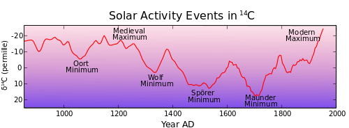
Solar activity events recorded in radiocarbon. Present period is on left. Values since 1950 not shown: Wikipedia

http://en.wikipedia.org/wiki/Maunder_Minimum

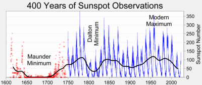
The Maunder minimum in a 400 year history of sunspot numbers: Wikipedia

http://sc25.com/index.php?id=268&linkbox=true&position=10

Image Attachment

The excellent historical weather chronology covering 1800 years put together by James A Marusek shows that the period between 1790 and 1820 was characterised not only by colder weather but also by violent fluctuations of seasonal weather. An extract of the chronology during the Dalton minimum is here: (weather chronology Dalton).

I give little credence to AGW Alarmism and the doom-saying regarding the effects of carbon dioxide. Environmentalism which was (and still is) highly admirable when concerned with the improvement of local conditions went off the rails when it went “global” and came to be dominated by the overweening arrogance of ignoring the sun and the presumption of super-computers and inadequate computer models.  Rather I am persuaded about the dominance of solar influences on the chaotic system which is our climate.

Whether or not a grand solar minimum is on its way, we are in for a decade of two of reduced activity and a cooling trend during this Landscheidt minimum.

Piers Corbyn forecasts a 3rd solar-influenced wave of snow in UK

December 23, 2010


Reproduced from Climate Realists.com:
Image Attachment

A THIRD period of “Solar Climate Change” on the UK will take place from Christmas Day to the End of December, this comes right after the first & second periods correctly predicted by WeatherAction.com & Piers Corbyn

The forecast made in November says….Snow deluges and blizzards in most of England and Wales, heaviest in East parts. Snow showers in Scotland. Sleet/rain and less cold in far West Ireland.

This “triple hit” of “Solar Climate Change” announced to WeatherAction.com users in November, means that the UK will go on to complete the “worst ever” December for High street retailers and business with the lack of essential public service due to road/rail/airport closures and again bring the country to it’s knees, and with “road salt” running out fast this “third” wave will take it’s toll on the “holiday” work force.

This is likely to add to one of the worst if not THE worst period of disruption in the UK to have been seen in modern times.

I will repeat what was said on the previous statement as this will still apply….

There are potential “life threatening” conditions that will be underestimated by the media (inc. Met Office).

With the aid of this forecast we hope to give some advance warning to those of you who are already suffering hardship and warn you of a very real risk of further and even bigger snow storms and blizzard conditions set for Scotland & England and Eastern Europe.

Please spread news of this forecast to all of those who are vulnerable and try to ensure that food supplies are sufficient to cope with this impending crisis.


Global warming arrogance takes “credit” for the white-out in Europe and the White Christmas in Australia

December 21, 2010

It used to be that the Global Warming zealots warned about the possible disappearance of snow and the mild and wet winters to come in Europe. But their arrogance knows no bounds. They have changed their tune and irrespective of what weather may prevail they mange to put it down to Global Warming. They now put the coldest December in a hundred years and the current white-out across Northern Europe down to Global Warming.

That snow outside is what global warming looks like

James Delingpole at The Telegraph is lauging his socks off.


Not to be outdone, the SMH thinks the possibility of having a White Christmas during the height of Australia’s summer is also due to Global Warming!!!!

The Alarmists cannot live with the thought that man made effects are puny and inconsequential compared to the effects of the sun.

Mild winters, warm winters, early winters, coldest winters in 100 years are all quoted in defence of global warming dogma.  They are all merely grist to the mill of Global Warming arrogance.

Science has been left behind in some far and distant galaxy.


Snow Chaos

December 21, 2010

Just returned from India via Frankfurt through Europe’s coldest December in over 100 years.

Two successive flights to Stockholm were cancelled (due to snow and the logistics of getting aircraft and crew to the right places) and I finally made it home with a delay of about 12 hours. Not too onerous.

But nothing unusual for Stockholm’s Arlanda airport  where operations continued without any fuss at -10°C and masses of snow. Flights cancelled from Arlanda were only those to the UK and Frankfurt!!!!

Heathrow

Heathrow snow chaos


UK snow: Christmas cancelled for travellers as Heathrow warns of days of delays

Heathrow authorities effectively cancelled the Christmas plans of hundreds of thousands of travellers yesterday as the Transport Secretary admitted the chaos at Britain’s busiest airport was “not acceptable”.

Amid mounting criticism of Heathrow’s response to the weekend’s snowfall, airline passengers were told to expect delays and flight cancellations “beyond Christmas Day”.

Snow and ice grounded two thirds of flights at Heathrow yesterday, with Terminals One and Three becoming so congested that passengers were told to stay away.

Only one of the airport’s runways was open and staff had cleared just half of the planes’ docking bays. All short-haul flights were cancelled. Some travellers faced a fourth night sleeping in terminal buildings in the hope of getting on a plane.

But even if the next Ice Age is coming I have no doubt that human ingenuity will ensure a successful adaptation.

Coldest December in 135 years

December 18, 2010

Kallaste december på 135 år

says the Svenska Dagbladet

http://www.thelocal.se/30914/20101217/

Power outages, traffic accidents as well as train and flight delays have left Swedes reeling from Thursday’s snowstorm, which forecasters say isn’t over yet.

“Slippery conditions will continue across the country. There is already a lot of snow on the roads,” SMHI’s Elin Torstensson told the TT news agency.

She explained that Sweden has experienced more cold days and more snow than is normal for December.

“There were a number of days in a row with below-freezing temperatures, so called ice days. And that we have that before Lucia (December 13th) hasn’t happened in more than 100 years,” she said.

Meteorology agency SMHI has issued a class 1 warning covering all of northern Sweden due to the large amounts of new snow, combined with the strong winds.

The agency also forecasts that the snow will continue throughout much of the country on Friday. Snow showers are expected to continue throughout the weekend over parts of Götaland and southern Svealand in central Sweden, with light flurries forecast for the north of the country.

“We’re expecting about five centimetres of new snow,” said SMHI’s Torstensson. Temperatures on Saturday are expected to range from a few degrees below freezing in Götaland to -25 Celsius in the far north, before cooling somewhat on Sunday when temperatures in the northern Sweden may dip down to 35 degrees below zero.

Weather not climate of course, but the credibility of so-called climate science is disappearing with its alarmist  displays of arrogance.

Winter variations and global warming

December 16, 2010

After a week in Southern India with minimum nighttime temperatures of around 20°C and maximum daytime temperatures of about 28°C, I am now in Delhi where the minimum nighttime temperature is about 5°C and where the daytime maximum touches about 25°C. Without widespread central heating being available, Delhi feels cold and on the streets everybody is bundled up in woollens, jackets, scarves and blankets and the occasional Balaclava.

In the meantime, Scandinavia and the UK and Northern Europe are bracing themselves for another cold wave and much snow. Next week I shall be back in about minus 20°C.

Swedish winter

Humans thrive in daily variations – every day – which range from 10 to 20°C and seasonal variations of temperature – every year – of 40 °C and sometimes upto 50°C.

The global warming doomsday scenarios seem  puny and nonsensical in the face of human adaptability and ingenuity.

A good thing that Cancun didn’t do too much and deferred everything again but of course the jamboree can – and will – continue next year in S. Africa. But “global warming” is going out of fashion and I have the gut feeling that climate alarmism is beginning to be seen in perspective.

Since the 1970s, the long-term rate of global warming has been around 0.16C a decade but that slowed in the last 10 years to between 0.05C – 0.13C depending on which of the three major temperature record series are used.

Global warming has slowed down in the past decade

Earliest winter in 50 years

November 30, 2010

Östergötland Sweden: image buscainmobiliarias.com

Here in the Östergötland region of Sweden, we have about minus 10 degrees Celsius today and the snow is thick on the ground. Folkbladet reports that winter has not come so early in over 50 years. It was back in 1965 when the winter came almost as early as this year.  Looking out over the current postcard like winter landscape the doomsday scenarios painted at Cancun yesterday seem not only surreal but also lacking common sense.

Free translation:

Winter came early to Norrköping this year. In fact, it has not been this early in 50 years. An unusual weather condition is to blame for the sudden start of
winter 2010.
Until this year 1965 was the earliest winter in common memory. Then the ground was covered with snow on November 14th. In 2010 we recorded the first “snow chaos” on 10th November. And since then the blanket has only become thicker and thicker. “We now have nearly 30 cm of snow”, said Jon Ekwall at SMHI (Swedish Meteorological and Hydrological Institute).

In 1965 we had “only” 7cm of snow on November 29th with a temperature of minus 8 degrees. Today it is minus 10 degrees.

The reason for the winter coming so hard and so early has not yet been analysed deeply. Meteorologists do not see any impending doom or any link to climate change either.
“We do not really know why we get this weather situation. It is only chance, “said Linnea Rehn, meteorologist at SMHI. “We have a weather situation that allows it to be colder than usual. Normally, there is a pressure over Iceland and a low pressure over the Azores, and this pressure difference means that you get a gentle western breeze blowing in”, Linnea explains further. “But at the moment the pressure difference is not as large as usual leading to the cold winds blowing down from the north into Sweden”. And Linnea adds that today’s temperature is much lower than normal. The average temperature is 8-9 degree below zero instead of being around zero.

And so a new record is set in the common memory.

Heavy November snowfall in China as well

November 27, 2010

Scandinavia and the UK are not alone in seeing November snowfall and bitterly cold temperatures – the coldest November in 15 years.

China issued a “blue” alert as heavy snowfall battered most of the north east of the country for a second day.

People walk against strong wind in Jilin City, northeast China's Jilin Province, Nov. 27, 2010. Snowfall hit most parts of the province from Friday night. Local meteorologic authority has issued a blue alarm against cold wave Saturday morning. (Xinhua/Zhu Wanchang)

The National Meteorological Center issued the blue alert for snowstorms on a second consecutive day as heavy snowfalls hit southern and eastern Heilongjiang and neighboring Jilin Province in the east on Saturday reports Xinhua. China has a four-color snow warning system: red, orange, yellow and blue. Blue is the least serious level.

But of course this is weather – not climate.


Antarctic sea ice extent almost 3 SD’s higher than “average”

November 25, 2010

Source:

http://nsidc.org/data/seaice_index/images/daily_images/S_stddev_timeseries.png

The Southern Hemisphere is coming into summer but seems significantly cooler (and wetter in Australia) than usual.

The ice extent in the Antarctic is reducing much slower than normally and currently the sea ice extent is about 1.3 million sq. km or 9%  or 3 Standard Deviations higher than the 1979 – 2000 average.

The Pacific Oscillation – or La Nina – is probably responsible.

Lowest November temperature since 1995, negative NAO drives frigid polar air over Sweden

November 25, 2010

Last night the temperature in Northern Sweden dropped to -37 Celsius, the coldest temperature recorded for a November day since 1995.

Bitter winter on the way: expert

24th November 2010 - Photo Fredrik Sandberg / Scanpix


“This year’s winter can be just as cold and snowy as last year. Now, as then, there is a weather phenomenon that causes cold air from the polar regions to plummet over us”,

writes the Svenska Dagbladet

The North Atlantic Oscillation is in a negative phase (NAO-).Before last year’s winter this had not occurred in years. The default mode instead was of the NAO  in a positive phase with the warm southwest winds, which resulted in mild, almost snow-free winters in northern Europe.

“Now it looks like last winter. If it continues, it means bitter cold. But you never know when the weather turns, “said meteorologist and researcher Per Kållberg at SMHI to Sydsvenskan. Meteorologists around the world are now discussing if the negative phase will continue. It started in December 2009 and has persisted since then, which is the longest period in over 40 years. Nikkaluokta in northern Lapland had  minus 36.6 degrees yesterday – the season’s lowest temperature so far, according to SMHI. It is also the lowest November temperature in Sweden since 1995.

The bitterly cold and long winter last year followed by the early start to this winter is, of course,  only weather – not climate.

But I expect in Cancun next week all the “believers” will be chanting their mantra of 2010 being a very warm year. Common sense will be notably absent of course.