Archive for the ‘Weather’ Category

The ice age cometh – Iceland has coldest summer in over 20 years

August 8, 2015

It is cool summers – not cold winters – which will be the harbingers of the coming of a little ice age. In the north of Iceland it has been the coldest summer in over 30 years (since 1983) and in the south it has been the coolest since 1992.

Iceland

IcelandMonitor:

The first thirteen weeks of summer this year have been the coldest in Reykjavik in over twenty years, reveals Icelandic meteorologist Trausti Jónsson.

The northern city of Akureyri fares even worse – one has to go back around thirty years to find a colder summer. Last year was Akureyri’s warmest summer in 67 years.

Summer in Reykjavik has not been this cold since 1992, although the summer of 1979 was by far the coldest. The warmest summer in Reykjavik in the past 67 years was in 2010.

Summer in Akureyri has not been this cold since 1983.

And meanwhile the UK summer has been pretty miserable as well:

Paul Homewood: As I indicated a couple of weeks ago, July has been another miserably cold affair, despite a couple of hot days at the start of the month.

The UK as a whole has been 0.7C below the 1981-2010 average, with the west and north particularly cool. In Scotland, it was the coldest July since 1998. This is the third cool month on the trot, making the May to July start to the holiday season the coldest since 1996.

Despite a mild winter and early spring, UK temperatures year to date are now running 0.2C below the 1981-2010 average.

Climate science (global warming) has lost the plot

August 3, 2015

When (not if) the next little ice age or even the end of this interglacial begins, we will first observe it by cooler summers – not initially by colder winters. While the “climate scientists” are chasing non-existent links between man-made carbon dioxide emissions and “global temperature”, they are reduced to data tampering and cooling the past. There is not a shred of evidence but only much conjecture that man-made emissions are of any significance.

They cannot predict the future so they are rewriting history. Every year the temperatures of the past are adjusted downwards. No model forecast of global temperature has come anywhere near predicting actual development. When the models don’t fit, it is time to dump the models. “Climate science” is now two decades out of date. Today Obama will announce another round of restrictions on the climate bogey-man – anthropogenic carbon dioxide emissions – even though his plans will have no impact on climate and will only make life more expensive.

The primary “forcing” or feed-back loop which will set off the little ice age or glacial conditions will be a reduction of ice melt over a few summers and followed by an increase of ice accumulation, which in turn will increase the solar energy reflected directly back into space. That will further reduce the ice melt in subsequent years. Cold winters and an increase of rate of ice growth is not required to set this off. Current, “normal” rates of ice growth in the winter are quite sufficient to reproduce the little ice age or even the return to glacial conditions provided that the summer melt is reduced and reducing. A large volcanic eruption with much dust ejected could well be the key factor to enhance the “forcing”. A year or two or three without summers in the higher latitudes could well be the key. It is probably of more significance in the northern hemisphere with its larger land mass which would support the direct growth of surface ice. In the southern hemisphere there is no reason that Australia could not also be covered with glacial ice sheets but more sea-ice would have to be created first. That would require much colder winters and not just cooler summers to trigger the change. It is not the climate near the equator or the tropics which controls. It is the regions above 50N and below 50S where we will first see the indications. It is the combination of reduced ice-melt followed by increased ice accumulation which will be critical.

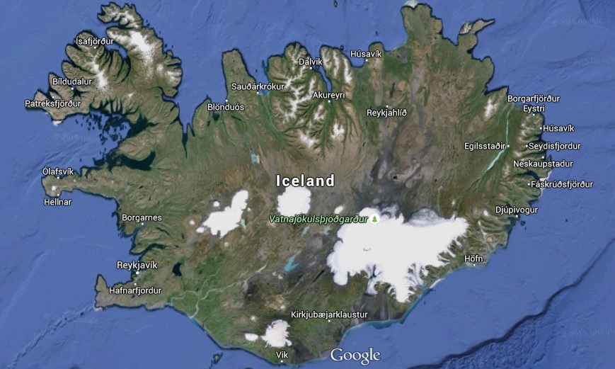
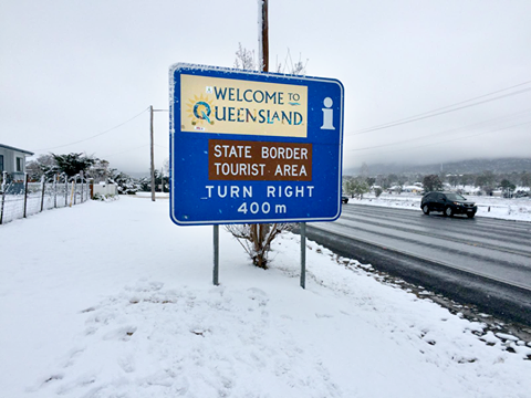
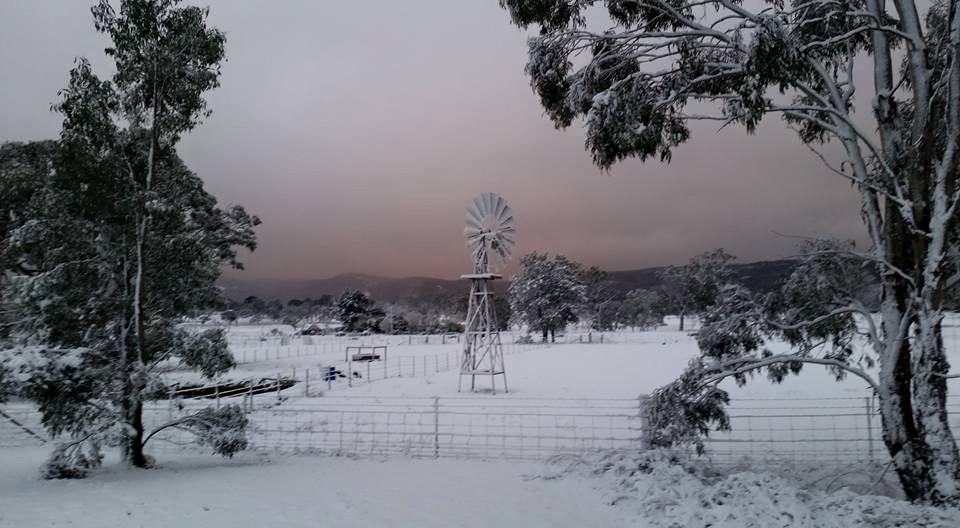
Here in Sweden it has been a miserable July. The Finnish summer has been the coldest on record – so far. It has been the coldest July in most of Australia in twenty years. Iceland has seen snow in summer which is not that common. Scotland is said to have seen its worst summer in 40 years. Montana, Wyoming and Idaho have seen anomalous summer snow. The Greenland ice melt started very late and seems to already have come to an end. “Freak” snow storms have come to the Rockies in July. Over 40 people and 250,000 alpacas died in Peru in a cold wave and Chile declared cold emergencies..

“Global temperature” is not a real thing. It is an artefact, a number calculated by massaging and adjusting real data. No matter what the self-styled “climate scientists” believe and worship, “climate change” which is not manifested as changes to local weather and which can actually be experienced probably does not exit. We are now in for 2 – 3 decades of cooling which will include a little ice age. But over the next 1,000 years we will also be back into glacial conditions.

Right now, I experience more indicators of cooling than of any warming.

And when the cooling does start – as it will – we shall be very thankful for the more than 1,000 years of fossil fuel reserves we have.

Snow in Hawaii in July – another omen of the coming ice age?

July 18, 2015

Mauna Kea gets snow in winter but not in July – when Hawaii is supposed to be sweltering.

The omens are gathering. The false prophets of global warming will tell us that cold weather is perfectly consistent with a warming Earth.We ignore these divine omens of a coming ice age at our peril.

Hawaii News Now:

While most of Hawaii experiences sweltering conditions this July, part of the Big Island might seem like winter after Mauna Kea got some snow overnight.

Officials have closed the road to the summit of Mauna Kea Friday after snow fell and caused icy road conditions. A ranger reported mixed rain and snow, fog and 1.5 inches of frozen snow on the summit.

IMAGE TAKEN ON MAUNA KEA – JULY 17, 2015 Hawaii News Now

Image: Mauna Kea Weather Center

Image: Mauna Kea Weather Center 17 July 2015

With another ice age on its way, thank goodness for fossil fuels.

More snow in Queensland and NSW than for a decade – harbinger of the coming ice age?

July 17, 2015

Carbon dioxide concentration in the atmosphere is the highest in modern times and has been increasing for well over a decade. But global temperatures – however that is defined – has shown no sign of warming and a slight decrease in that period. The Sun’s activity is down and reducing to levels similar to that of the Maunder Minimum in this Landscheidt Minimum. A new Little Ice Age is likely by 2030.

The small little signs of weather that are harbingers of the coming Little Ice Age are accumulating – even in the southern hemisphere. Australia is experiencing a “cold” wave (though +12ºC does not seem particularly cold). The cold wave is also giving “unprecedented” (for a decade) levels of snow.

It is inevitable that since the global warming priesthood have been preparing for the icecaps melting that we will now enter a new ice age.

Maybe this time the glaciers are going to spread in the southern hemisphere across Australia and South America?

SMH: Snow creates winter wonderland … in Queensland, as well as NSW


865,000 evacuated as Typhoon Chan-hom heads for landfall today

July 11, 2015

Close to a million people have been evacuated and almost 30,000 fishing boats have been recalled to port as Typhoon Chan-hom approaches Sheijiang on the East China coast.

CRIMore than 865,000 people in the eastern Chinese province of Zhejiang have been evacuated as super Typhoon Chan-Hom, the second typhoon to hit China in two days, approaches.

A total of 28,764 ships had been recalled to port as of 10 p.m., Friday, and several cities were already reporting heavy rain and strong gales, the provincial flood, typhoon and drought headquarters said.

The National Meteorological Center (NMC) issued a red alert, the highest level, on Friday morning for the super typhoon.

At 0900 local time on Saturday, the typhoon was around 115 kilometres southeast of Zhejiang province over the East China Sea and forecast to make landfall in Zhejiang on Saturday in the afternoon. It could be the most powerful typhoon to hit the area since 1949.

Image from Pacific Disaster Center:

Typhoon Chan-hom July 10th 2015

Typhoon Chan-hom July 10th 2015

“Global warming” on vacation as July temperatures rival last November

July 10, 2015

Reality seems quite different to the fanciful computer models of the alarmists. Where has the imagined global warming gone? Of course “global warming” is not something that can be experienced or observed. Global temperature is an artefact. It can only be calculated from “adjusted” and “homogenised” data where the past has been cooled and continues to be cooled with every year that passes. The algorithms used to adjust and homogenise real data seem to be designed to produce pre-determined results. From raw temperature data, there is no evidence of man-made global warming.

We had 3 days here in Sweden over 30ºC last week. The fantasists began talking about a “heat wave”. Since then it has felt like March or November. The maximum today will not exceed 13ºC.

(Note that in the UK, on one day last week – and based on one temperature reading at an airport – it was claimed that it was the hottest day for 200 years. Even if the sensational conclusion was correct – which it was not since it was hotter in 1976 – it would only demonstrate that it was hotter 200 years ago and long before man made emissions were of any significance).

DagensNyheter:

November Chill – in the middle of July
The summer warmth is conspicuous by its absence. And the mercury can hardly get to more than 12 degrees in Stockholm. It is as cold as last November.

The summer warmth will have to wait a good long while. Low pressures are relentless in Sweden – and today it is colder than in a long time. The temperature in Stockholm just before midday is about 12 degrees. It is as cold as the beginning of November last year.

“This is unusually cold and far below the normal temperature”, says Eva Strandberg, meteorologist at SMHI.

It does not appear that it will be much warmer anytime soon. “During the next 10 days or so it does not look like there will be any high pressure. The unstable weather will dominate and perhaps with a few days up to 20 degrees. There is a continued risk of showers”, says Eva Strandberg.

Climate can only be observed as weather

November 19, 2014

One weather event is not climate but climate can only be observed – ultimately – as weather. Climate is an integration of local weather over space and time. Supposed climate change which does not show up as changes to local weather to give conditions which lie outside the range of normal variability of that local weather, is no change.

Anthropogenic global warming when it is a conclusion which can only be based on “adjusting” raw data or is only that predicted by a model, but which cannot be actually observed, is of little relevance and of no importance. It is certainly a rather stupid basis for policy.

There has been no global warming of any kind (anthropogenic or otherwise) – even with adjusted data – for over 18 years. The anthropogenic component – supposed to be due to on man-made emissions of carbon dioxide – is not discernible, even though carbon dioxide emissions from fossil fuel combustion have increased by some 70% in that time.

The politically correct “policy” of reducing fossil fuel combustion would seem to be of no significance and of little relevance. This particular weather event in North America only adds to the body of evidence that is not consistent with global warming.

Reuters: All 50 U.S. states feeling freezing temperatures

Temperatures in all 50 U.S. states dipped to freezing or below on Tuesday as an unseasonably cold blast of weather moved across the country, while heavy snow prompted a state of emergency in western New York.

In the U.S. South, states were bracing for a record chill from the Arctic-born cold that swept the Rocky Mountains last week.

Every U.S. state, including Hawaii, was bitten by temperatures at the freezing point of 32 degrees F (0 C) or below, the National Weather Service (NWS) said.

A waterfall that doesn’t

October 26, 2014

From thisiscolossal.com.

Extreme Winds Cause a Waterfall in England to Blow Upward wind weather waterfalls England

Upflowing water fall

Hikers exploring England’s Derbyshire Peak District earlier this week stumbled onto a rare phenomenon caused by extreme winds. The River Downfall, a 30-meter (98 foot) waterfall was blown back almost vertically by a powerful updraft, making it seem as if the waterfall was simply flowing into nothing. Very cool. (via Twisted Sifter)


Extreme Winds Cause a Waterfall in England to Blow Upward wind weather waterfalls England

El Niño expectations have collapsed from “monster” and “super” to “weak – if at all”

September 8, 2014

Alarmists had a great time in spring this year as they looked forward eagerly to a “super” or a “monster” El Niño. For some the very foundations of global warming ideology was at stake. Global temperatures have not risen now for 18 years and have shown a slight decline for the last ten years. An El Niño was seen, by the more rabid alarmists, not just as another regular weather event (which we cannot predict very well) but as a way of shoring up their temple – an edifice that is now crumbling. Catastrophe scenarios for the Indian monsoon began doing the rounds.

And still they claim this is a settled science!

The alarmists such as Joe Romm went to town with dire predictions just 3 months ago and were predicting a “super” and a Monster” El Niño for 2014. Of course, dire predictions which never ever materialise are the stuff of alarmism.  The clever alarmist is the one who makes unverifiable predictions which will never happen but which cannot be disproved.

Joe Romm, 26th March:Is A Super El Niño Coming That Will Shatter Extreme Weather And Global Temperature Records?

Signs are increasingly pointing to the formation of an El Niño in the next few months, possibly a very strong one. When combined with the long-term global warming trend, a strong El Niño would mean 2015 is very likely to become the hottest year on record by far. ……. 

John Upton, May 16th:A monster El Niño could be on its way, and it will likely have a complicated effect on the world’s breadbaskets.

Something fierce is rising out of the Pacific Ocean, and its appetite for the world’s major carb crops could be even more ravenous than that of a monstrous mythical sea creature. …… A dinosaurian belch of warm water thousands of miles wide has appeared at the surface of the Pacific Ocean near the equator. The warming ocean conditions have spurred NOAA to project a two-thirds chance that an El Niño will form by summer’s end. It’s tipped to be of the monster variety—the extreme type that could become more common with global warming.

But they were all crying “Wolf” again. They will have to swallow their disappointment as the WMO has now reduced its expectations for El Niño to be just a “weak event if at all”.

ETThe World Meteorological Organization (WMO) now sees less chance of El Nino conditions forming this year than it did three months ago and expects only a weak El Nino event if it occurs at all, it said in a statement on Monday.

During El Nino events, surface temperatures in the central and eastern tropical Pacific become substantially warmer than normal, a phenomenon that is strongly linked to major climate fluctuations around the world and can last for a year or more. 

“Despite warming of the Tropical Pacific Ocean up until June, the overlaying atmosphere largely failed to respond. As a result, ocean temperature anomalies along the equator have decreased over the past two months,” the WMO statement said.

“Changes in the wind patterns in early-August brought some weak re-warming, but winds have now returned to near normal in the western Pacific, while the pattern of cloudiness has remained largely neutral.”

The downgraded WMO forecast follows a similar easing of expectations by several national weather agencies. The WMO, which aggregates data from climate models around the world and expert opinion, said Pacific Ocean surface temperatures may yet warm towards El Nino levels in the next few months.

It will not be a “good” Indian monsoon this year but rainfall has recovered during the second half and the official monsoon season still has 3 weeks to go. The current rainfall is on the edge of shifting from “deficient” to “normal”. (Green is normal and red is deficient. Blue is excess)

Monsoon status September 8th 2014

Monsoon status September 8th 2014

“Poor” Indian monsoon so far unlikely to derail growth

August 30, 2014

With one month to go for the “official” 4 month-long monsoon season, rainfall has been 18% deficient so far. At the half-way mark most states were deficient in rainfall. However about half the states have now crept back to “normal” rainfall. With any El Nino only expected to be weak – if it even actually develops – a catastrophic monsoon can now be ruled out. Rainfall will be below normal but the last month of the monsoon holds some hope for further recovery. There is also some hope that the monsoon – which developed about 10 days late – may also be delayed in withdrawing giving some rainfall into the first two weeks of October. It will still be a “poor” monsoon but may not be labelled “bad” or “catastrophic”.

IMD’s chart covering the 3 months so far is below. Green is “normal”, red is “deficient”, yellow is “scanty” and blue is “excess”:

Monsoon 2014 75%

Monsoon 2014 75%

There is still some risk that a poor monsoon will hold back the industrial recovery somewhat. The growth in the last quarter has been the highest for 2 years as sentiment has turned positive, and is not likely to be reversed by this “poor” monsoon.

BBC: 

India’s economy grew by 5.7% in the three months to June, its fastest pace in two-and-a-half years, according to an official estimate. The economy was helped by strong growth in electricity, gas and water supply, and financial services, the Ministry of Statistics said.

The growth figure was higher than analysts had been expecting. …

….. Ever since the Narendra Modi government took charge, business sentiment has improved on the ground. Investors have started pumping in money again, capital markets have been roaring, consumer demand has revived & hiring has picked up.

But this euphoria is primarily driven by sentiment and more steps would be required to sustain this optimism.